
Mathias Wuhr, CLS, ALS, NSLS, PEILS, NBLS
Interviewed by Les Frederick
Mathias Wuhr, known as Matt, was born on December 15, 1929, in Minto, New Brunswick. He graduated from the Minto Newcastle Consolidated School in 1946 and initially worked in the coal mines in Minto. In November 1949, Matt joined the Topographical Survey of the Department of Mines and Technical Surveys, where he spent two years working on various phases of topographic mapping both in the office and in the field.
In the summer of 1951, Matt worked on mapping control in Newfoundland. The following year, in 1952, he traveled to the Northwest Territories with the Legal Surveys Division to survey the highway right-of-way west of Yellowknife. In 1956, he completed the examinations for the Dominion Land Surveyor commission, the same year he obtained his Alberta and Nova Scotia Land Surveyor commissions. Matt continued his work with the Legal Surveys Division, spending several summers surveying settlement surveys in the Arctic and surveying Indian Reserves and national parks in Alberta and British Columbia. Additionally, he earned his Prince Edward Island Land Surveyor (PEILS) and New Brunswick Land Surveyor (NBLS) commissions.
Matt retired from the Legal Surveys Division in September 1989, concluding an event filled career. He passed away in Ottawa on July 21, 1999.
In 1999, Matt’s wife, Yvonne, donated nearly 1,600 color photographic slides taken by Matt to the Alberta Land Surveyors’ Association (ALSA). A prolific photographer, Matt used his trusty Voigtlander 35mm cameras to document his surveys. His photographs capture mountain peaks climbed, bush cleared for boundary surveys, prairies and Arctic tundra. They also depict settlements such as Hay River, Cambridge Bay, and Holman Island in the Northwest Territories and Nunavut, showcasing a time when different survey methods and equipment were used, including dog teams, horse and sleds, snowmobiles, helicopters, and float planes.
In 2023, the Wuhr family graciously donated Matt’s cameras to the ALSA, preserving a piece of surveying history that reflects the significant contributions Matt made to the field.
The transcript of the following interview has been edited for length and clarity.
ORAL HISTORY PROJECT
Interview Summary
Accession number: 1:1 Date: July 8, 1999
Interviewee: Matt Wuhr, CLS, ALS, NSLS, NBLS, PEILS – MW
Interviewer: Les Frederick, ALS – LF
Place: Mr. Wuhr’s home, 2129 Navaho Drive, Ottawa, Ont.
Number of tapes: 1 Dictaphone tape (original only) poor quality. Total Time: 34:50 min.
Conditions: None
Note: Mr. Wuhr died shortly after this interview on July 21, 1999
Minutes Transcript – prepared by Les Frederick
_____________________________________________________________________________________
LF: This is July 8th, 1999. l’m in Ottawa in the home of Mathius Wuhr and l’m interviewing him. Mathius, what is your full name?
MW: Mathius Wuhr.
LF: What was your father’s name and your mother’s name?
MW: Mathius Wuhr was my father, Mathilda (Zimmerman) Wuhr was my mother.
LF: Where were you born?
MW: Minto, New Brunswick.
LF: Were any of your forefathers surveyors?
MW: No.
LF: What got you interested in Surveying?
MW: A job.
LF: Where did you start, in New Brunswick?
MW: Well I was working in the coal mines, seen this poster on a board in the post office and it said “map makers” wanted for Ottawa. I always liked maps. The field of surveying was on the side. So I applied and wrote exams in Fredericton and then months later they said to report to Ottawa, November I, 1949. So I came here.
LF: How old were you then?
MW: 19. I passed high school and I was in the coal mines and the merchant navy on Queen Charlotte Islands. When I seen this poster when I was back in the coal mines and I says “Boy, that’s right up my alley,” so I came here.
LF: Who did you work for when you came to Ottawa?
MW: The name of the director was Palmer and he shipped me down to Bill Landles a great friend who had just started recently.
LF: And that is when you started surveying?
MW: Well, they had me on mapping and horizontal control for a while but I didn’t like that pin pricking and so I raised shit. I said “as soon as I raise enough money I’m getting the hell out of here.” They put me every fall up in the Gatineau area doing all the Gatineau Hills and then they brought me in 1951, we flew the first choppers into Newfie. We did half of Newfie mapping in 1959, no 1951 because Newfie joined us in 1949. So we went there with the two helicopters.
LF: What kind of instruments did you use?
MW: T1 ‘s T2’s.
LF: And all chaining?
MW: No, mostly triangulation. We mapped half the province.
LF: How many crews?
MW: Oh, we had a training crew- must have been four of us.
LF: Where did you stay?
MW: We moved to trains and our equipment all the time.
LF: So your base was the train?
MW: Yeah.
LF: With a cook car and a camp car?
MW: I’ll show you this… (showing map of campsites).. Deer Lake. Took the train over most of us but we were the first choppers to fly across from Cape Breton to Newfie.
LF: How long were you there for?
MW: May till the end of September.
LF: So this was for the Federal Government?
MW: Topographical Surveys-just part of the legal.
LF: So were you articling at that time?
MW: They told me the best route for me to go was to become a DLS. I wrote my exams and I articled under various men.
LF: How many exams did you have to write?
MW: I think there was 6 in the articles and 12 in the finals.
LF: So you became a DLS first?
MW: Yeah, and then became an ALS.
LF: So what got you out to Alberta?
MW: Mountains.
LF: So after Newfoundland you went to Alberta?
MW: Yeah.
LF: ls that with the same topographical survey?
MW: No, that was with the legal. As soon as I got my articles, I had to go to Alberta and finish them off because I missed one exam in DLS and I had my choice then so my first place of surveying was Waterton.
LF: What were you doing there?
MW: Town sites – the whole town.
LF: The town site of Waterton – what year was that?
MW: 1955.
LF: So that book there, is that all your…
MW: Spring 1955, these are all the places l surveyed. Itemized.
LF: Everywhere you went you wrote it down.
MW: Yep, from there I went from Waterton to Banff that year. Deer Lodge, Yoho National Park, cemetery at Jasper, sub-division of Alexis, Duncan Indian Reserve.
LF: How long were you in Alberta?
MW: Up till November 28, 1955. May 24 to November 28.
LF: And then where did you go?
MW: The next year l just got back into Ottawa and they wanted me the next year on the 34th Baseline the last one and I ran west from the 6th meridian. We ran it from the 6th Meridian over to Trout Lake. That was a bastard.
LF: 34th baseline from 6th Meridian west to Trout Lake.
MW: Yeah.
LF: Why was it a bastard?
MW: Well in tents it was 70 to 80 below.
LF: Oh, you did it in the winter?
MW: Yeah.
LF: So November 21…
MW: l got there on November 21, 1953. My final day there was April 14, 1954.
LF: So from November 21 to April 1954.
MW: That was a bugger.
LF: Cold. You stayed in tents?
MW: Yeah, tents, snowshoes, planes every couple of weeks.
LF: To drop supplies?
MW: Yeah. That was a tough one. George Paulson supervised us. Crazy.
LF: So how many man crew was that?
MW: Oh, one cook, two men on line, 2 chainers. I don’t know. Twenty of us anyways.
LF: So cutting line by axe.
MW: By axe only. We never had power saws. Some days we’d get a half a mile, some days six depending on the bush. But George Paulson came in. I’ll never forget George in his buffalo coat. Four of us in a tent. Jeez.
LF: What do you mean?
MW: Well there was three of us assigned to a tent. Put our fir boughs down after we came in from the line after we pitch our tent. Every 6 miles we would move our tent. We didn’t know where it was and George said “don’t bother, will ya, come with me.” So we walked with him. Christ we got more lost. But to start the 6th Meridian off until we knew where it was, we used aerial photographs and I made a beeline across Catalina Lake. Said “the hell with him.” I was just a young buck but I knew I was right. And I fell into an overflow. Oh boy, we really froze up in those days. And I got to the other side and dried off, and we found it. We could have started over there instead of 6 or 7 miles away.
LF: Why did George come up?
MW: He was sort of an inspector. One baseline was going east and one was going west.
LF: How did you find out where to start?
MW: By the old maps.
LF: The meridian was already run?
MW: Yeah, but once you got on the ground it was a different story (…?) fly markers at the ends – try to find those red ribbons. Once we found a pit and mound or one of those witness pins we were off and running. Took a bearing on Polaris (…?)
LF: That’s something that I’ve never had the opportunity to do. I’m really interested in how you guys actually did it. So you would find your 34th Baseline on the meridian …
MW: Yeah, we had to go out to a certain section and township.
LF: Right, then you’d take off, take a bearing on Polaris and then turn a 90 or 270 and then away you’d go and then cut line..
MW: Yeah, every 6 miles. That was meant for future of oil companies. I don’t know if they ever used it.
LF: So every 1/2 mile you were digging pits and mounds.
MW: Every 1/2 mile, yeah.
LF: What about the buffalo coat?
MW: We had a buffalo coat from the national parks -George Paulson – it stank to beat shit. He’d wear that everywhere he was going – slept in it, ate in it. He’d never get over it. He slept alongside of me, holy shit! Smelled. 70 below outside and a hot little stove inside. We were all spaced in and it smelled up everything.
LF: What kind of food did you have up there?
MW: Well they brought in supplies mostly bully beef, spuds, the cook was a good one -Kyle Sanderson from Fort Vermilion and he knew how to bush cook. He did it for other surveys. He was good.
LF: So they brought in supplies every two weeks?
MW: Every two weeks. lt was frozen. Holy shit, it was really frozen.
LF: Did you do any hunting when you were up there?
MW: No, we weren’t allowed to but we seen some caribou but we never shot them. Cause they brought in slaughtered meat from cows- bones cut out. They’d always cut the best steaks and whatnot off. So we didn’t have to eat off the land. Good job because there was nothing there.
LF: Did you have 3 meals a day or just breakfast and dinner?
MW: When in camp we had breakfast and dinner and then work all day with a lunch.
LF: You don’t get much daylight up there in the wintertime?
MW: No but we did pretty good. You had to walk about 6 miles to your line, 6 back in the dark but when you’re out there, when the sun comes up, you give her hell. Most of those guys ran their lines on pickets. And they were pretty well right on.
LF: When you were running your baseline, did you have your link chain?
MW: Both, we had to have a link chain, we had to have a foot chain.
LF: So every 40 chains, you dug your pits and mounds and then you’d put in your post, set up on that…
MW: No, we would keep right on going let the mounders tell me the exact spot.
LF: So where would your instrument be?
MO About a 1/2 mile ahead but sometimes way back. I didn’t like that particular survey because I was about 20 some years of age and they applied what they call a snow like when you get a snag in a tape they put the weight of the snow on a tape that wouldn’t shake off. I didn’t like that but they put us through (…?) and added it on. I wouldn’t trust that baseline because you couldn’t shake the snow off it so we measured and measured but maybe it did good. Anyway 1/10000 at that time. We tried our best.
LF: Most of the baselines are very good. I’ve always admired the old surveyors that did those in the conditions.
MW: But we had good mounders. They were on previous surveys. They dug them right. The only thing I found out after we left the survey, completed a couple of years afterwards was there was forest fires all along that wherever I went to set up the instrument -might be 2-3 hours and wherever the boys had lunch they had a fire or two and the fire went down into the permafrost and spread out.
LF: So the baseline plan has your name on it?
MW: Pete Timoschuk’s
LF: So you were articling to Peter Timoschuk?
MW: Yeah, 1955 the year I became an ALS. ln 1952 we did all the Mackenzie Highway from the 60th Parallel to Hay River. That was the most mud…
LF: Swamp? ln the summer time?
MW: Yeah. We had two campsites. May 10December 18 of 1952 we were out. Timoschuk came from Saskatchewan. He had a farm there. So we did all the, what do you call that type of roadway where you put logs across?
LF: On the muskeg?
MW: Yeah, it was the old army road. If you see a truck coming, you put yourself right smack in the hole and they couldn’t get by. They had a winch. He had to pull you out forward and let him by and keep on going. Took us about a week to get up there and we got to the 60th Parallel. Not far from there we set up some tents. So we surveyed that whole goddarn road and I don’t know why to this day. Then we did a right of way that same year from Snare River down to Yellowknife. That was all by aircraft. Yes, there are a few stories to tell about bush pilots.
LF: Tell me some.
MW: Well, one of them came in on a mirror lake at night time. Naturally he misjudged went right in the bushes and he sat on one float and I sat on the other and said “Jeez we had a rhubarb!” But we had a nice ramp to roll up on of rocks. He sat and smoked on one float and I on the other for about an hour. I didn’t say nothing to him. He was in it making money you know. So we rocked her back in. The boys are 5 or 10 miles away around the bend. We got the motor going and skimmed over there and this guy the bush pilot said to me. He said “Don’t tell anyone in Yellowknife what I done eh or they’ll razz the shit out of me.” Well, I said “No, but you sure scared the shit out of me!” We got over there and the next morning he came out and his plane’s sunk right up to the white tips all the ribbons went underneath.
LF: What was his name?
MW: I don’t know. lt’s in my diary which is at the office. You know.. diaries are only meant for Dominion Land Surveyors. He was a French guy. Sea floats cost as much as a plane. Then there was another guy took me way back – that’s way later on and he crashed my plane. Same as the guy in Newfie – crashed my helicopter because he went to sleep on a hill top while I was trigging over to another station. Then he said he could probably take it over there – he had enough gas. Halfways over – no gas. So he auto rotated down and away she went. They all went in to get some parts off the plane. But on this winter job we blew the engine all to hell -one motor when we were landing. That’s because he wouldn’t wait for air bottles to come up from Edmonton. He wanted to get our load up so…
LF: What job was that?
MW: That was the baseline – the very last job. Very last when we pulling out equipment.
LF: What do the air bottles do?
MW: They’re called the oleos. They’re like shock absorbers so they put in hydrogen and when they hit the snow… Who’s that famous pilot? Ernie Boffa. Came in later with a Norseman and picked us up a day later. We were lucky to get out of there…goddarn aircraft with nobody hurt. Mechanic was worried because his job was Fort Smith and the other guy was based out of Edmonton. He made them put the goddarn plane together – Associated Airways then they made them fly the goddarn thing to Edmonton to see if it was airworthy. They fixed him – no job.
LF: So how did it crash?
MW: Well, when we came in, that snow and ice is just like real heavy. So one of them just couldn’t take it -blew her right up. I was looking at the motor finally all of a sudden there was no top of the motor. So we threw all of the switches, got out of her and waited for her to blow. Didn’t blow. Yeah, thank God for Ernie Boffa who reminds me, flew us into my first job to Pine Point. ln Pine Point there was only a small airstrip and one guy guarding it in a cabin. There was 6 or 7 houses there. That’s all. Look what it became and look what it is now. It was a real Shangri-La when I last seen it and after that they told me they took everything out.
LF: I’ve never heard of Pine Point
MW: Well, Pine Point is just south of Great Slave Lake. Yeah, you go down by Alexander Falls and eastwards. We did small town sites.
LF: What’s your most memorable survey in Alberta?
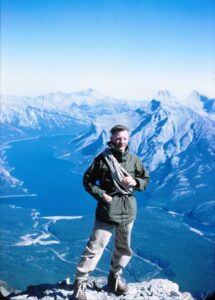
MW: Well that’s hard to say. Because I’d say the co-ordinate control of all Banff was the most memorable. Had to climb all the mountains, then put all the base points in. I understand they did it all over again which is natural. I climbed Mt. Cascade by myself and to see if the top of (…?) monument was there. Later on we got a chopper cause we were on fixed incomes. I got caught in a thunderstorm up there. I never thought I’d get off.
LF: All by yourself?
MW: Yeah.
LF: With your equipment?
MW: No we brought another guy first with the equipment and plodded over and I went up the next day and stayed up there and hung out. And when I put the instruments on the tripod would be like this. When I came this close to them fire was flying right out of my finger nails. I said “holy shit, what’s going on here?” All blue flames every time I drew away. Then I could hear this zip zip zip all around me and the smell of ozone. “Holy cripes, I’m just one lightning rod!” So I radioed down below to Banff. They told me you better get the hell away. Take your belt off. Take everything off go hide yourself somewhere. I did that. Watched the beautiful lightning all round me.
You asked most memorable. Co-ordinate control network-Banff. That was 1966. You see the others weren’t important as to see the country. I tried out the winter survey and the next thing I got back here in April and they wanted me out again for another one -the Saskatchewan North West Territories Boundary. I told them go take a jump. I says I froze my feet, froze my hands, froze my nose, froze everything. I said I’m not going back no more. Not in those conditions. I say I wouldn’t go put a coal miner in that stuff. “Oh, it will enhance your reputation. Bullshit! You can fire me right now, l’m not going back. ”
LF: So who did you article under for your ALS?
MW: Pete Timoschuk and Lorne Anderson who went to the Yukon May ’15 to October 3. We did mineral claims all on Yukon Territories up in Keno. He was good.
LF: And you got your commission in 1955?
MW: Yeah, before I came back to Ottawa. I went from the Alexis Indian Reserve and wrote to (Carl) Lester and who’s this other guy? Two top men. There was (Carl) Lester and Jeez so long ago. He was one of their top men in all of Alberta, too. (Jack Holloway)
LF: So did you write your exams in Edmonton?
MW: Yeah. I just had one – two, the Alberta license for land surveyors and the other one. They gave me a written one and an oral one. I’d say the oral was the toughest. I think I had Lester beat because I read all his manuals for all his write ups CIS manuals kind of knew what he was going to ask for.
LF: So Lester was asking you questions?
MW: Yeah, and the other guy. They were pretty knowledgeable, damn good men. Asked you how to set up a transit in a bog. You know stuff like that. Crazy questions but knowledgeable in theory in the bush.
LF: So then you came – after Alberta – you came back east?
MW: Then I came back east and wrote my finals in Ottawa. And l was on my own.
LF: Was that the last time you were back in Alberta?
MW: No, I had many many jobs at least 2 or 3 times. Then I asked for – being young-“give me the jobs that the married guys won’t do.” Toughest. So I did them all.
LF: You weren’t married at the time?
MW: No, so I said I don’t mind. Stupid foolish. So they put me all everywhere. Then they got me to do the parks in Alberta. -Yoho, Glacier, Revelstoke because the BCLS wouldn’t do it. No one would do those jobs so I did them. Pictures of me and Walter Perrin, a Swiss guide, and Jimmy Simms, the Parks Superintendent climb the highest mountain they had in Yoho. Nobody else would do it. We roped up, put in a monument and came back down. We were tough.
LF: So how long would it take you to climb a mountain like that -10,000 ft.?
MW: Well, from the elevation of 4000 take – we’d get up there about 1 o’clock left 2 o’clock in the morning.
LF: 2 o’clock in the morning you would leave?
MW: Yeah.
LF: So you would leave a picket up there?
MW: There was a rock post put in, then we put a strong picket held a big cairn over it. lt’s all in that book. Take a look in that 57 journal you’ll see the three of us. That’s when I think we did it. We’ll have to have a look. Jeez my mind must be going because he was with me yeah. Yoho National Park – west boundary. That’s it look in the 1958 diary. Canadian Institute of Survey. They always publish the year afterwards.
LF: So you were up there in 1957?
MW: According to this, Yoho National Park – west boundary – Kootenay, Glacier, Revelstoke and I went right up to other places – Bushe River, Whitefish. I always thought Tommy was with me but he wasn’t but you can see it there. See they publish that for each department geodetic, topo, hydro, and they put in the best pictures for propaganda. Now that was one of the worst but as I say one of the other ones was that co-ordinate control. Now in ’56 I did quite a bit in Elk Island, and Banff, Spray Lakes. Ya-Ha Tinda Ranch. Lots of levels of Lake Louise. That was quite a one. Take us from the bed from the railroad CPR right up to the chateau. Lake Louise in 1956.
LF: Running levels?
MW: Yeah. They wanted to know the elevation of Lake Louise compared to the railroad. Why, I don’t know. But we did it. I pounded a post in the flat wall right below the piano in the ball room of the Chateau Lake Louise put the elevation on it. He came out and gave me shit. He said “What are you doing that for?” l said, “Well, I was ordered to do this.” He said, “Well, l’m going to change your order. You’re disrupting our concert. I said, “l can’t help it.” We got her in. Then he left us alone.
LF: You put your elevation on the post outside the ballroom?
MW: Yeah. lt’s still there too. Then I did all Waterton Lakes National Park. Yoho.
LF: What the boundaries?
MW: Yep. I was sent later on back. That was when Ken Allred decided to become a surveyor. Most of these are additions to Fox Lake, Bushe River, townsites, whatnot, all in Northern Alberta.
LF: So you did a lot of surveys in Alberta?
MW: Oh Yeah. 1959 was the Waterton Lakes Boundary. Then I did all of Fort Smith. We left Waterton Lakes went right up to Fort Smith and that was a high flood zone.
LF: Where did you live when you were doing all this?
MW: Most of the time was – we always carried our sleeping bag. Every place we went. Sometimes it would be a jailhouse along the MacKenzie River with the Mounties. They kept it nice and clean. Sometimes with the French Missionaries. I’d pay them.
LF: But you were based in Ottawa still?
MW: Oh yeah.
LF: So how long were you usually gone?
MW: From May until way into September
LF: So then you worked in Ottawa for the winter?
MW: Yeah. Then we’d get set for the next season. Then my Dad was dying in ’59. I heard of it in Banff so he lingered for 2 more years and I asked to go to Nova Scotia ’cause I had their license. So they sent me down there and I did Louisbourg and a lot of Indian reserves in Nova Scotia. So in ’61 he died so I went back to Alberta and I did Banff again ’cause everybody knew we had Banff and Eden Valley. That’s the home of the stampede. Your western stampede really started at Eden Valley. So we stayed there. Did Eden Valley, then went over to Bassano to the Blackfoot Indian Reserve. That was horrible. Hot! You thought it was hot here. Cook a god darn egg on your trucks there. What a waste.
LF: Why?
MW: Well, we didn’t have the tellurometers. We didn’t have anything.
LF: When did you start using EDMs?
MW: Not until I got to Louisbourg. They only had one or two for 20 crews. Had to have a priority.’62 l went to Rocky Mountain House then l went up to Hay River. I did Hay River, Fort Resolution, Fort Providence, Rae, Stagg River, Yellowknife, Lac la Martre, Nahanni Butte, Sean Marie River, Wrigley Settlement, Fort Chip., Samson, Blackfoot. We did all these up there.
LF: You were up in Fort Chip?
MW: Yeah, move with the geese. When the geese would go up I’d go with them. When I saw the geese starting to fly south, I said, “lt’s time to go.”
LF: You’ve been a lot of places.
MW: Yeah.
LF: Do you ever regret being a surveyor?
MW: No. You regret it at times just like any job.
LF: When it’s 70 below?
MW: No, the worse it got the better I liked it. The thing that got me was being sent into zones that I knew was flooded and useless ground. But they were adamant they were going to do it. I couldn’t understand why. Yeah, that road when I first started off in ’52 the old road around Lesser Slave Lake and you had to go up that way. That was corduroy road they called it.
LF: Corduroy – the logs?
MW: Yeah logs across that the army did. See they kept on going that way. They had to strike up that way.
LF: ls that when they were putting in the CANOL pipeline?
MW: They were going to Norman Wells. Norman Wells over to CANOL with the pipeline. There’s a place – barrels and barrels and barrels in the wilderness of gas and supplies, trucks, jeeps.
(First side tape ends)
(Second side of tape)
MW: …..Max Ward. I remember when he just had small floats in Yellowknife. Starting off. He flew us up, by geez, lots of places. By taking short runs _ _snowdrifts, whatnot, and ah, he was good. Then he took me in his Bristol Freighter. Holy Geez! I thought we’d never get out of Cambridge Bay. I understand that Bristol Freighter is the one they got rigged on the pedestal up at the museum at Yellowknife, at the airport. But Max was the type of guy, get to know you and he’d recognize you in his Edmonton hotel. He’d drop his exec’s right off. “Come on with me, Matt. We’re going to go”, and we’d have a drink. Whatever you want. He’d leave them all. Yea. Did that to everybody that helped him.
(Pause) (looking through papers) I always meant to organize my stuff. That was in Newfie. Holy geez, I got a bunch of photographs to put together. This is in England when I was there. Anyway, on the Mackenzie River, truckers would always stop at our camp because there was a coffee and lunch. Carl would always bring out anything they wanted. They’d bring in the beer. We were happy.
LF: What year would this be?
MW: I’d have to take a look. That was 51, I know that.
LF: This is your camp?
MW: Yea. These are our choppers that flew in Newfie. These are all Pigeon Lake. That’s one of the winter jobs. I have thousands of photographs down the basement, all in colour. There’s a friend of mine on a cut line. These are digging the pits. I climbed a tree to show them how we set up pits. Gee, I didn’t know I had all these here.
LF: This is your Manual of Instructions?
MW: That was it.
LF: Well used.
MW: Yea.
LF: Did you do any wellsite surveys?
MW: Ah, the odd one in the Indian Reserve. We never touched anything outside. Now, the best place I ever had food by mustn’t exclude these missionaries. They were very good. We stayed in their old cabins -all torn down now -, but they were neat and clean and that one at Fort Providence was exceptional. The nuns cooked for us and we really had a great time there and had a chance to talk to these men. Very highly intelligent. From France.
LF: So, what would it cost to stay in one of those?
MW: I paid them the same that it would cost me to be in a hotel. Price of the hotels weren’t cheap at that time. So I gave them the same for the meals. They didn’t want it. “No, no, dollar a night.” I said, “No, no. You’re going to get the same as wherever I went. You’re kind enough to take us in.” So they took us all in.
LF: All twenty of you. How many guys were there?
MW: Oh, when I was doing the small surveys, there’d be only four of us.
LF: So small surveys you’d have what, an instrumentman, a chainman..
MW: I was the instrumentman, an assistant and two students.
LF: Two students?
MW: Yea.
LF: Were they articling?
MW: Then you’d hire as you go. No, none of them took an interest in. They were glad to get out of surveying. Pound, pound, pound your head off. Iron pins and you didn’t know what for. Making roads where there was no cars. Not even a wheelbarrow. But this particular year, l did two jobs. So, then I went back again to New Brunswick because my first born, he’s 31 now. So I worked and got my NBLS. Then I went over and did Fort Anne, Port Royal, Sydney.
LF: So when was the last time you were in Alberta?
MW: Just trying to see. 1965. See, some of these surveys conflict because I’d be in Alberta, do a summers job, then I’d come back to Ottawa and Yvonne was in New Brunswick so I’d say, “Well, I’ll go down and take a look at those jobs”. Nobody else wanted to stay out so I’d go and visit the jobs. I went down to Cape Breton National Park, Louisbourg. There’s a job nobody wanted to do, Louisbourg. The first mineral claim survey according to law that was ever done in Nova Scotia.
LF: What did you use for calculators? Log tables?
MW: First we had log tables. All we had. Then they gave us the Curta. We thought that terrific. Jesus. And then finally they came out with calculators. Much better. Spent all night working on logs. Jesus. Getting dizzy. So when these other ones came along, go faster and faster. Naturally. When they gave us a power saw, holy shit. Couldn’t believe that.
LF: What year was that?
MW: My first power saw came with me on a job in British Columbia which they had. That was when I did Revelstoke. We cut those big trees down but they were always bunging up, but Louisbourg is where we needed them. That’s where we got them. Said if we didn’t get them, we’d quit. Time to take the bull by the horns. No, in the mountains, we never used them. Too dangerous. If a guy ever cut himself…
LF: How long were you with the government?
MW: Forty years.
LF: What was your favourite story over all the years you’ve been working?
MW: Just meeting a bunch of good guys, I guess.
LF: That makes all the difference, doesn’t it?
MW: Makes the world. You come back in. You shoot the bull about what you’ve done. You don’t tell the others what you do. So we had a good bunch of guys until they regionalized. Then we busted up. But there’s one guy who will forever remain. That’s Gordie. He gave me that plaque. He always sent me a Christmas card. That plaque down below it with the five commissions I got from the office. But that one up above is either Mount Rundle or Cascade –exceptional job. Stan Hutchinson gave me that. Yea. But I was always made welcome there. Now, if you have any other questions, go ahead.
LF: No, I was just curious about what your favourite survey was but I think you’ve answered a lot of them.
MW: Well, there was so many of them.
LF: Yea, l know.
MW: So many fascinating. What always bugs me though was we never really got into the history of an area. We’d finish a job -away you’d go. Never gave you a chance and you got to read it in books afterwards. You see there’s a lot of places you admire if you like wilderness. Snowdrift was one. A high top of a mountain sitting by yourself was another. Your thoughts seem to go in a different way. Snowdrift was one I liked. I always liked this spot and some spots I didn’t like naturally. But Banff, we always made sure we got there in the spring before the tourists. Come back after the tourists had gone. So it looks normal.
LF: Well, I’d like to thank you very much for this. It was very fascinating.
MW: I don’t know if I helped you much.
LF: Oh, yes you did. Good stories.
(Interview ends)
Interviewed by Les Frederick on July 8, 1999
Copyright 2024 © Alberta Geomatics Historical Society