Names from the Past:
Allan Poyntz Patrick, PLS, CE, DLS/DTS, LS(BC), JP, ALS.
By Glen Belbeck
This summary of AP, as some of his friends called him, outlines the life of an Alberta Land Surveyor with one of the longest survey careers in Canada, spanning from 1869, when he articled with Robert Sparks, PLS, in Ottawa, Ontario, until he fell down some stairs in his Calgary home in 1943 at the age of 93. While his broken hip healed, AP ceased his formal surveying activities later that year, ending a 74-year stint as a surveyor!
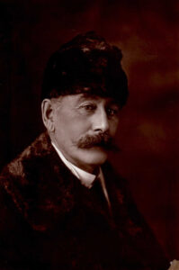
A.P. Patrick – taken before December 11, 1915 (Unknown photographer.) Provided by Mary Park, great granddaughter, on February 19, 2021.
Patrick was born in Montreal, Quebec, Canada East, on July 18, 1849, to a family deeply involved in running the government of Upper Canada and then the Province of Canada. Raised in Toronto, Canada West, and Quebec City, Canada East, educated first at the Galt Grammar School and then at Upper Canada College, AP also certainly trained at a “School of Cavalry and Artillery” in Toronto, one of the forerunners to the Royal Military College in Kingston, likely in 1868. He secured an articling role with Robert Sparks’ survey firm in Ottawa in the summer of 1869, while still an officer in the local Militia. Chief Engineer Sandford Fleming hired him to be part of the CPR railway route survey crew in Northern Ontario in June 1871, as an Assistant Leveler.
In April 1873, AP received his Provincial Land Surveyor’s (PLS) Certificate for Ontario. By that August, the firm of “Sparks, Wolff and Patrick” (SWP) was formed, with AP as PLS and CE (Civil Engineer). The next year, Allan found himself in Manitoba and the Northwest Territories as part of the Special Surveys Group under Lindsay Russell, whose crews were promulgating a triangulation network west from the Prime Meridian towards the 2nd Initial Meridian. During the bitterly cold winter of 1874/75, Russell’s crews extended a baseline east across Lake-of-the Woods for later use in the surveying of “DLS-like” townships in Northern Ontario. AP was back in Ottawa at the firm of SWP (Provincial Land Surveyors, Civil Engineers and Draughtsmen) by early 1876. In November 1877, AP received his Dominion Land Surveyor (DLS) commission and his Dominion Topographic Surveyor (DTS) designation, passing the DLS exams with high marks, and was given Commission #8.
Major A.P. Patrick, an excellent marksman who won second place among perhaps 900 entrants in a shooting tournament in 1876, was then employed by the Federal Government. His initial instructions were to perform Treaty 7 Indian Reserve surveys, topographical surveys of rivers, and other boundary surveys as needed, mainly in the District of Alberta, Northwest Territories. He and his assistants left Ottawa on May 15, 1878, about the same time as his former colleague at Robert Sparks’ firm, William Ogilvie, PLS, DLS was also heading west. Their destination was the capital of the Northwest Territories – Battleford, on the North Saskatchewan River. Patrick and Ogilvie left Battleford in early August 1878, heading for the “Forks of the Red Deer” and “Blackfoot Crossing,” respectively. Patrick was charged with surveying the boundary of the South Saskatchewan Reserve on the west bank of the South Saskatchewan River, just above its confluence with the Red Deer River. When he started his work on that proposed Reserve, AP was just the second DLS to work on boundary surveys in what we now call Alberta. W.F. King, DLS, was the first to survey a boundary in Alberta – near Fort Edmonton in September 1877.
If this South Saskatchewan Reserve is unfamiliar to you, there is a good reason! AP had ridden into the middle of a territorial dispute. The Forks of the Red Deer was the location where three treaties met – Treaty 4 on the east, Treaty 6 on the north, and Treaty 7 on the west. An important chief of the Cree, Big Bear, as yet not a signatory to Treaty 6, did not want part of what he considered Cree hunting/wintering grounds surveyed. A Calgary Herald article from February 12, 1938, records AP’s recollection of what happened next. Big Bear impounded AP’s horses and equipment. AP was able to coax his favourite horse back at night; then, he and his horse headed south, swimming the South Saskatchewan River on their way to Fort Walsh in the Cypress Hills. Thirty North West Mounted Police (NWMP) returned with AP to discuss things with the Cree. The result: the survey of the Reserve was halted, assistant John C. Nelson, odometer in hand, returned with most of the NWMP to Fort Walsh, and Patrick and the rest of the crew headed for Fort McLeod with a couple NWMP as escorts. Other than a future intention on government maps, no record has been found of a completed Reserve survey at the Forks.
There was less drama for the rest of the 32 months Patrick spent in the west that decade. Initial surveys were made of a Peigan Reserve on the Old Man’s River, a Stoney Reserve on the Bow River, two Government farms near Pincher Creek and Fort Calgary, and river surveys for the Kootenai, Belly, Old Man’s, Willow Creek, and Big Bow rivers. In a report penned at Fort Walsh in January of 1880, A.P. Patrick stated that they had been out of Ottawa for 608 days, surveying 974 miles by odometer, 447 miles by chain, and 330 miles by pacing. Patrick finished a Reserve Survey at Elkwater known as the “Head of Cypress Mountain Reserve” in early 1880, as soon as the heavy snows of the winter of 1879/80 melted, then worked on six other Treaty 4 Indian Reserve surveys before returning to Ottawa in December of that year. He and his boss, Edgar Dewdney, Indian Commissioner since May 1879, had some sort of falling out, and AP’s days working for the Federal Government came to an end. AP noted in a December 1880 report that his knowledge of the Blackfoot language allowed him to talk directly to the chiefs, bypassing the untrustworthy interpreters. This ensured that what the chiefs wanted for their reserves was what was surveyed.
AP spent the next few years ranching west of Calgary on 22,600 acres he secured as a grazing lease, called Mount Royal Ranch. He met his future wife in that area, a well-connected lady named Maggie McPherson (one quarter Cree/Chipewyan). Maggie was the niece of Donald A. Smith and Isabella Hardisty. Donald helped finance the CPR in the early 1880s, was the driver of the “Last Spike”, and later called Lord Strathcona. Maggie was also the niece of Richard C. Hardisty – future Chief Factor of HBC’s Fort Edmonton, and later Senator for the District of Alberta. Maggie was also the first cousin to James A. Lougheed, later known as Senator Lougheed and grandfather to Alberta’s Premier Edgar Peter Lougheed. AP was involved in the 2nd Riel Rebellion of 1885, probably as part of the Home Guard for Calgary, and received land in what is now SW Calgary for his service. AP named that Military Homestead “Plateau Farm” and built a house there for his new bride.
In 1888 AP established an office in downtown Calgary as a DLS. On July 16, 1890, AP received permission to practice land surveying in British Columbia as an LS. In 1891, AP started working for the Land Titles office in Calgary as a “temporary clerk” – that job lasted until early 1897, when he left Alberta for a time to set up a survey office in the Revelstoke, BC, area. But he returned to Calgary in late 1898, after allegedly surveying the original townsite for Burton, now located under water in Upper Arrow Lake. Patrick’s new Calgary survey office was located downtown, above the Calgary Herald office. It flourished between 1901 and 1913, peaking in 1907 when Patrick registered over 80 plans of survey. Patrick is remembered for “Patrick’s Points”, a simple yet effective method of documenting lot lines/corners in downtown Calgary using holes drilled into the new concrete sidewalks that started to be installed in the first decade of the 20th century. A significant part of his firm’s activity was linked to the development of many townsites along the Calgary and Edmonton Railway line, from Leavings/Granum in the south to Wetaskiwin in the north. AP’s clients for these townsites were normally land developers, such as Augustus Meredith Nanton (Land Agent for the C&E).
This is a photograph of AP and his crew performing a survey for Calgary Power in 1907 at the peak of his activity as a DLS in Alberta.
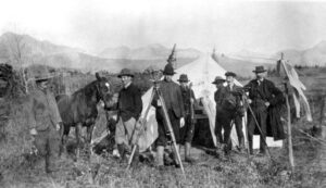
Glenbow Archives NA-1115-4 (1907) – Survey Camp on Ghost Dam, Cochrane, Alberta (AP on right)
Concurrently with his survey career, Patrick was heavily involved in oil exploration. Acting on the hint of petroleum he was shown in 1879 west of Waterton Lakes, AP staked claims along what is now called Cameron Creek, and across in BC along Kishinena Creek, as early as 1889. He and two partners, George Leeson and John Lineham, drilled there in late 1901. They struck oil in late 1902 – the first successful oil well in Western Canada! AP’s fascination with the industry lasted until well past his 80th birthday. During that same year – 1902, AP was appointed Justice of the Peace for the NWT. He retained the title “JP” until at least 1940.
The Attorney General of Alberta had decided any DLS who resided in Alberta as of December 16, 1910, could be registered as an Alberta Land Surveyor (ALS). AP was commissioned as ALS # 30, effective January 1, 1911. A.P. Patrick was Vice-President of the ALSA for the years 1911-1913. In April 1912, he sat on the Alberta University Board of Examiners for Land Surveyors. As his survey practice grew quieter in 1914, AP became an Alderman in Calgary, winning an election in December 1915. He served in this capacity until he resigned in late 1917 to be on a Military Tribunal to hear claims of those wishing to get out of conscription for Military Service. AP’s training in the Military School in Toronto, his membership in the Militia in Ottawa as a Major, and his continuing title after retirement from the Military in September 1879 as “Retired Captain Allan Poyntz Patrick”, and the respect of the people of Calgary, made him an ideal candidate for the role of Tribunal member.
After the Great War, Patrick’s survey activities grew quiet – he registered only 11 plans of survey between 1919 and 1927. As AP approached 80 years of age, it seems he tried to retire in 1928. But Patrick Oil Company was formed in early 1930 to redrill the early discovery at Waterton, with AP as Honorary President. Later, AP focused on his garden in the yard of his home on “Millionaire’s Row”, on his hunting dogs, on his bridge game, and on his family. After his wife Maggie passed in 1940, AP welcomed his children into his big house to live. AP died at the age of 98, on April 09, 1948. One of his grandchildren, Allan F.J. Spence, spent part of his career at the Land Titles Office in Calgary (1949-1979).
This summary is largely taken from the 2022 book “Calgary’s Grand Old Man” (ISBN 978-1-7779967-0-3). A copy is accessible at: Calgary Public Library; University of Calgary; Didsbury, AB Museum; Empress, AB Library; Eatonia, SK Library; Battleford, SK Museum; and Library & Archives – Ottawa.
Author: Glen Belbeck, Calgary
April 1, 2025
Copyright 2025 © Alberta Geomatics Historical Society
Originally published in the Baseline The Newsletter of the Alberta Geomatics Historical Society. Vol. 1 No. 3, March, 2025.