Leaving an Indelible Imprint on the Prairie Landscape
By Gordon Olsson
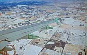
Have you ever viewed the arable land of the Canadian prairies from an airplane window and wondered about the hundreds of miles of square parcels laid out in a checkerboard pattern? It is the result of the Dominion Land Survey System – a survey system that was planned in order to supply land for homesteaders moving to the prairie provinces after the acquisition of Rupert’s Land in 1870. Survey before settlement, as the saying goes, provided the structure and information required for the rapid and orderly settlement of the prairies.
A Vast Territory to be Surveyed and Settled.
Before Confederation in 1867, western Canada was a land of First Nations and Métis peoples and fur traders. Under the Royal Charter of 1670, the Hudson’s Bay Company controlled trade and the administration of land in this region known as Rupert’s Land, which was the area from which water flowed into Hudson Bay.
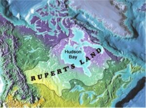
When the Hudson’s Bay Company surrendered Rupert’s Land, the Canadian government made it a priority to survey western Canada into orderly parcels.
The Hon. William McDougall, Minister of Public Works, asked Lieut.- Col. John Stoughton Dennis to develop a system of survey. Dennis studied the rectangular system used in the United States which contained sections of 640 acres (one square mile). While retaining the basic concept of a rectangular system, he recommended and obtained approval for a system containing townships of eight miles square divided into 64 sections. Each section contained 800 acres, probably to conform when divided into quarters to the 200 acre lots used in Ontario¹. In 1869, even though the formal transfer of Rupert’s land to Canada had not taken place, Dennis who had been joined by Milner Hart and Major A.C. Webb began laying out the survey late in the season. At that time, the Metis were discontented because of their lack of representation in the political changes that were happening, and they were concerned that the survey would jeopardize their land rights. On October 11th, Webb’s survey party was stopped by a party of Métis led by Louis Riel while surveying a base line for the survey. That incident brought an end to the survey and the Red River Resistance soon followed.
A cooling down period followed the Red River Resistance. In 1870, Rupert’s Land was formally transferred to Canada and Manitoba became a province. In 1870, after being appointed Surveyor General of Canada, Lieut.- Col. John Stoughton Dennis returned to the Red River area to collaborate with The Honourable A.G. Archibald, Manitoba’s first Lieutenant-Governor to further develop and refine the land survey system. Instead of the 800 acre section originally proposed, Archibald recommended sections of 640 acres, which was formally adopted by the government. One reason given was that the 640 acre section used in the United States was known all over the world to the emigrant classes, but perhaps the most convincing argument was that a section of 640 acres would furnish 32,800 homesteads while a system using 800 acres would provide only 25,000.
In 1871 the first surveyors manual was issued by Surveyor General Dennis and surveying recommenced during the summer of that year.
Laying out the Dominion Land Survey System
Using the forty ninth parallel, which was the Canada-US boundary, as the first base line, surveyors were able to establish a framework of meridians and base lines for the survey. The work required careful measurements and accurate astronomical observations for longitude, latitude, and direction. This framework provided the control necessary for a virtual army of surveyors to survey vast areas into townships, sections, and quarter sections in a relatively short period.
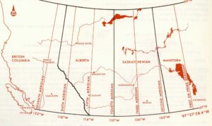
McKercher & Wolfe, Understanding Western Canada’s Dominion Land Survey System, 1986
Seven meridians, run astronomically north from the forty ninth parallel, were created to layout the township system. The first meridian called the Prime Meridian is just west of Winnipeg at longitude 97° 27’ 28.4”. The Second meridian is at longitude 102° W. with successive meridians, 4 degrees longitude apart. The boundary between Saskatchewan and Alberta is the Fourth Meridian. The Fifth meridian is just east of Calgary.
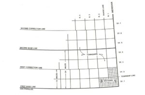
Visions of an Ordered Land (Gilmore Surveys)
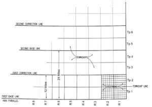
The forty-ninth parallel being the international boundary is the first base line. The second base line was established four townships (24 miles plus road allowances) north of the international boundary. Then base lines were established at intervals of four townships. From base lines, two townships were laid out to the north and two to the south.
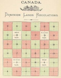
Diagram showing the division of a township into sections. Each section is 640 acres (one square mile) and is further subdivided into quarter sections of 160 acres.
A township is composed of 36 sections plus road allowances and is approximately six miles by six miles. Each section is approximately one mile by one mile and is further subdivided into quarter sections. Townships are numbered northerly from the international boundary. The system of quarter sections, sections, townships, ranges and meridians has been established throughout most of the arable land in the prairie provinces. The system allows for easy identification of any particular unit of land. For example, the quarter section of land encompassing the Royal Tyrrell Museum near Drumheller, Alberta, is identified as NW 1/4 of Section 21, Township 45, Range 18, west of the 4th Meridian.
The 1872 Dominion Lands Act provided for one-twentieth of the lands in the Fertile Belt² to be reserved for the Hudson Bay Company. Sections 11 and 29 were set apart for the purposes of funding education. In 1881, an Act respecting the Canadian Pacific Railway provided for a grant of 25,000,000 acres for the costs and operation of the Railway. The Railway grant comprised of odd number sections extending 24 miles on each side of the railway. There were many exceptions, and the law with respect to the allocation of the land was modified several times over the years.
As the survey moved westward minor modifications were made to the system, primarily to road allowances. Most townships in Alberta are in the Third System of Survey where road allowances are one chain (66 feet) wide.
Range and Township Roads
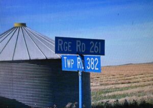
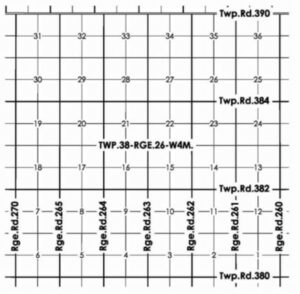
A range road is a road running in a north south direction along the boundary of a section. The numbering system for range roads uses the range in which the road is situated and the section to which the road is adjacent to on its east side. For example Range Road 261 is in Range 26 between Sections 1 and 2.
A township road is a road running in an east west direction along the boundary of a section. The numbering system for township roads uses the township in which the road is situated and the tier of sections immediately south of the road. For example Township Road 382 is in Township 38 between the second and third tiers of sections.
Correction Lines – They’re Not a Mistake
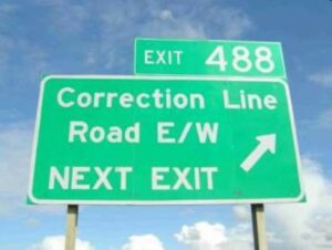
As townships are laid out to the north and south of base lines with the east and west sides following lines of longitude, the sides of townships and sections converge on the north side of a base line and diverge on the south side. As a result townships and sections laid out to the north of base lines will be narrower than those laid out to the south of baselines. The difference in width results in roads that “jog” midway between the base lines at correction lines.

Jog in Range Road 214 on the correction line between Townships 50 and 51in Range 21 West 4th
Meridian. Image from Google Earth
The Dominion Land Survey System was the outcome of over a multitude of surveyors working over several decades. It is certainly the largest area in the world encompassed by one inclusive survey system. It provided thousands of homesteads in a peaceful and orderly manner. As a simple and practical method of land identification, it became the framework for controlling land-related information and managing natural resources, like oil and gas. The Dominion Land Survey System, along with the Torrens System of Land Title Registration used in Alberta, is one of the most stable, efficient, and effective land survey systems in the world.
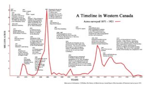
Chart showing the annual acres surveyed from 1871 to 1921
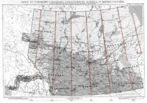
Map showing the extent of the Dominion Land Survey System up to 1929
After the transfer of natural resources from the federal government to Alberta in 1930, the provincial government took control of surveys on Crown lands.
This article touches on events leading up to the original land surveys and describes the system. However, there is much more still to be told. The effect of these surveys on First Nation peoples and the Métis was not insignificant, as were some of the technical and logistical challenges that the surveyors had to overcome.
References and Further Reading:
- Don W. Thomson, Men and Meridians, Vol 2, 1967.
- Warkentin and Ruggles, Historical Atlas of Manitoba, 1970.
- MacGregor, Vision of an Ordered Land – The Story of the Dominion Land Survey, 1981.
- McKercher and Wolfe, Understanding Canada’s Dominion Land Survey System,1986.
- Larmour, Laying Down the Lines: A History of Land Surveyors in Alberta, 2001.
Author: Gordon Olsson, ALS (Hon. Life)
October 6, 2024
Copyright 2024 © Alberta Geomatics Historical Society
[1] Warkentin and Ruggles, Historical Atlas of Manitoba, 1970, p.232
[2] The Fertile Belt was bounded on the south by the United States’ boundary; on the west by the Rocky Mountains; on the north by the northern branch of the Saskatchewan (River); on the east by Lake Winnipeg, the Lake of the Woods and the waters connecting them.
