

29. 1960s to 2000s – A Period of Change
By Gordon Olsson
In the preface to the series of articles about the collection it was stated that many objects in the collection depict the greatest evolution in land surveying technology in history – the period from about 1960 to the 2000s.
The preceding 28 articles covered survey instruments and other objects that were used up to the 1960s. For the most part, they had not substantially changed from the first industrial revolution. The Gunter’s chain designed and introduced by Edmund Gunter in 1620 was used for property surveys for over 350 years. Even though the steel band tape was introduced by the Chesterman Company in the late 1870s, the Gunter’s chain remained in some instrument maker’s catalogues into the 1940s.
What about the measurement of bearings, azimuths and angles? The surveyor’s compass (circumferentor) was used in the 19th century in North America. However, at the end of the century, governments required greater accuracy and bearings were to be astronomic. As a vertical circle was required to take astronomic observations theodolites were required. Theodolites can be traced back to the sixteenth century in Europe. They evolved over the years with a significant improvement occurring in the 1920s when Heinrich Wild developed the optical theodolite, however they remained basically the same, an instrument with a horizontal and a vertical circle.
The first logarithmic tables were published in 1614, which simplified and reduced the time for computations. The invention of hand-cranked mechanical calculators in the 19th century enabled calculations to be made faster by using natural trigonometric functions. However, surveyors still used logarithms (until the curta arrived) as the small savings in time did not warrant carrying heavy hand-cranked mechanical calculators into the field.
The message above is that although over three centuries there were some technological improvements in measurement technology and calculation functionality, there was little substantial change that affected land surveying.
That all changed in the mid 20th century. Several labels have been given by pundits to the period of change that started then: the “digital revolution,” the “scientific-technical revolution,” the “information age,” the “telecommunications revolution,” and the most encompassing of all, the “third industrial revolution.”
Whatever name is given to this period, land surveying profoundly changed during it. Initially measuring was made easier, faster and more accurate with electronic distance measuring instruments (EDMs). Very early computers took over from logarithms and mechanical calculators which opened up new innovations such as automated plotting. Then total stations were introduced that measured distances and angles electronically and provided measurement and other data in digital form which could be downloaded to computer programs by means of data collectors. Eventually, the Global Positioning System (GPS) arrived. All that was required to obtain a position was a clear view of satellites.
For land surveyors, this new technology – particularly GPS – propelled a change from relative accuracy (the relationship of one monument to an adjoining monument) to positional accuracy (the position of a monument in relationship to a spatial reference system). Ratios of errors were eventually replaced by confidence regions in determining accuracy. Large databases evolved which included coordinates of monuments. These facilitated geographic information systems that integrated all sorts of spatial information. Coordinates also made locating and defining property boundaries easier.
The following articles in this series will describe and illustrate some of the surveying instruments, computers and positioning instruments and other devices that are in the Alberta Geomatics Historical Society historical survey artifact collection that were developed during this period.
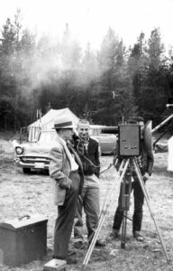
Carl Lester, Director of Surveys for the province of Alberta from 1951 to 1964. In the picture taken in 1959 he is testing a Tellurometer, then a new electronic distance measuring (EDM) instrument.
AGHS Historical Photo Collection: 10. Lester Photos/Miscellaneous(1)/020
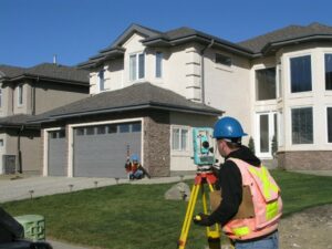
Using a total station for real property reports.
AGHS Historical Photo Collection: 20. Pals Surveys, 2008.10.14/005
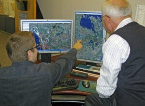
In the 1990s, geographic information systems evolved that integrated all sorts of spatial information. In the photograph cadastral data is integrated with Google Earth imagery.
AGHS Historical Photo Collection: 21. CCCM Office Pictures 2008-10-15/ 2490
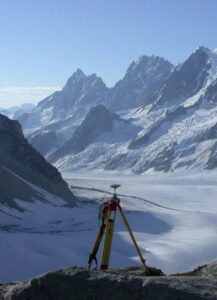
GPS facilitated surveying and mapping in mountain regions and helicopters enabled access to control stations in minutes. Prior to the advent of GPS, surveyors had to measure baselines and through triangulation obtain the position of stations high in the mountains. Prior to helicopters, several hours of climbing were required to access control stations. If the weather turned bad, the work had to be abandoned and the station returned to another day.
AGHS Historical Photo Collection: 30 Focus Surveys ALSA 2008.13.01/Tiedemann control
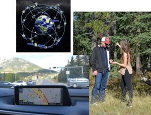
GPS became ubiquitous. Vehicle navigation and route finding for hikers are just a few its many applications. Top left is Navistar GPS Satellite Network.
AGHS Historical Photo Collection: 31 Olsson/1g.
Sources of Information:
- Wikipedia, the free encyclopedia/Digital Revolution
Author: Gordon Olsson, ALS (Hon. Life)
September 4 2022
Copyright 2024 © Alberta Geomatics Historical Society