
05. Surveys were to be Astronomical
By Gordon Olsson
It was common to use magnetic bearings for surveys during the 19th century using a circumferentor or surveyor’s compass. However, magnetic bearings are subject to local declination and the location of the magnetic pole changes over time. Magnetic bearings are also subject to local deviation caused by nearby sources of interference. Therefore, magnetic bearings were not practical for the Dominion Lands Survey, with the largest area covered by a single survey system in the world, where the controlling lines were to be meridians of longitude and parallels of latitude.
The 1871 1st Edition of the Manual of Instruction for the Survey of Dominion Lands[1] specifically stated that surveys were to be astronomical, “performed independently of the magnetic needle.” Paragraphs 4 and 5 on page 11 specified the instruments to be used. Theodolites of a higher standard, reading to at least ten seconds, were required for the controlling lines of the township system (baselines, correction lines and meridians) than those required for internal subdivision lines. For internal subdivision work, “a transit, theodolite, or solar compass reading to minutes” was deemed sufficient.
The solar compass had attachments that enable the determination of north by reference to the sun. If a solar compass was ever used on the Dominion Lands Survey, its use was not widespread and, in later editions of the manual, reference to its use was dropped.
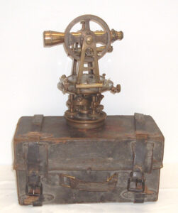
E.R. Watts and Son Theodolite, London, Eng. Ottawa 7, Winnipeg, No 3726. The company E.R. Watts and Son was established in 1856 in London, England. A review of a 1910 E.R. Watts and Son Limited catalogue, indicates that it was likely made in 1910 or earlier.
The source is unknown.
ALSA 2007.02.01
Tripod ALSA 2007.02.01
On December 31, 1879, a memorandum was issued to accompany the existing instructions for the “Survey of Standard Meridians and Parallels forming the outline of Blocks of Sixteen Townships.” This memorandum elaborated on the theodolite requirements and also stated that, for astronomical work, the surveyor must be provided with a sidereal pocket chronometer.
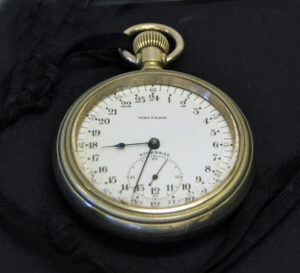
This Waltham Sidereal Watch was used by A.G. Stewart ALS#078. Mr. Stewart worked on the survey of the Alaska-Canada boundary before working in Alberta in 1910. He was chief surveyor for the Land Titles Office from 1920 to 1936. During WWII, he worked on the Canol Pipeline, after which he built up a private survey practice in Edmonton which eventually became Stewart, Weir, Stewart, Watson, Heinrichs and Dixon. He was an honorary life member of the Alberta Land Surveyors’ Association.
Donated by C.H. Weir, ALS
ALSA 2007.27.02

The image above is from an advertisement on page 4 of a 1911 Topley Company pamphlet “Instructions covering Astronomical Field Tables for the use of Engineers and Surveyors.” A.G. Stewart’s sidereal watch is identical to the Waltham sidereal watch shown in the pamphlet.
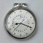
There are no markings on this sidereal watch. The case for the watch is inscribed B.M. Rustad, ALS. Bjorn Rustad ALS#229 came to Canada in 1950 from Norway and spent most of his surveying career working on baseline, meridian, and township surveys in northern Alberta with the Director of Surveys office. He was an honorary life member of the Alberta Land Surveyors’ Association.
There is no record of who donated this item.
Sources of Information:
- Surveyor General of Canada Lands Website: National Standards / Historical Publications / Dominion Lands manuals: 1stEdition 1871 and December 31, 1979, Memorandum to accompany Instructions for the Survey of Standard Meridians and Parallels forming the outline of Blocks of Sixteen Townships.
- ALSA Website: Alberta Land Surveyors’ Association History. A.G. Stewart, B.M. (Bjorn) Rustad.
[1] The 1871 Manual designated the lands as Public Lands of Canada in Manitoba and the North-West Territories. The lands were not called Dominion Lands until 1872, pursuant to the 1872 Dominion Lands Act.
Author: Gordon Olsson, ALS (Hon. Life)
October 14, 2021
Copyright 2024 © Alberta Geomatics Historical Society