
17. On the Bubble – Wye and Dumpy Levels
By Gordon Olsson
Land surveyors who mainly do boundary surveys only occasionally are required to do survey level work. However, most if not all engineering projects require the determination or laying out of elevations. During the period of rapid development in western Canada accurate levels were run along the railway lines and levels were taken along meridians and base lines for the Dominion Land Survey.
The Dominion Lands Survey was more than surveying western Canada into townships and sections. It also provided intelligence in the form of topography and suitability for agriculture and natural resources. Leveling played an important part in collecting the information. From the Department of the Interior, Annual Report of the Topographical Surveys Branch, 1913-14:
“Five thousand three hundred miles of line have now been levelled by surveyors of meridian outlines and base lines in the western provinces. As a result, much information previously lacking is now available for dealing with future extensions of railways, utilization of water-powers, improvement of navigable rivers, drainage, and development of natural resources. The results show that many areas of wet land, reputed to be of little value, can be drained readily into neighbouring streams, and become fit for agriculture.”
Jonathan Sisson introduced a wye level in London in the 1720s. In a wye level, the supports for the telescope are shaped like the letter Y. The level will be in adjustment when the line of sight is parallel to the axis of the bubble. In a wye level the bubble is centered and the telescope is sighted on a distant target. The clips holding the telescope are then released and the telescope reversed in position (like a carpenter level). It is re-leveled and again sighted in the direction of the target. If the line of sight is on the same position on the distant target the instrument is in adjustment. If it is not the leveling screws are adjusted and the process repeated until it is in adjustment. Wye levels were preferred over dumpy levels on account of their easy adjustment and superior accuracy.
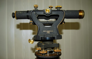
William Gravatt introduced the dumpy level in 1830. A dumpy level is fixed in its supports. Only the level bubble can be adjusted. It was purportedly called a dumpy level because its’ telescope was short and fat. In reality the telescopes for many dumpy levels were no shorter or longer than those for wye levels. The dumpy level is less precise but more rugged than the wye level.
There are other types of levels which may be used in engineering or construction work. A builder’s or architect’s level will have a horizontal circle enabling horizontal angles to be laid out. Some levels had tilting telescopes enabling grades to be laid out for drainage, ditching and road making projects.
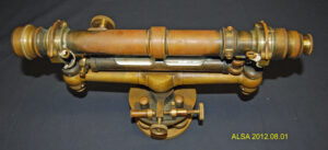
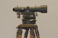
Level engraved “W & L.E. Gurley Troy NY.” “s/n 2155.” This Wye level has a 15” long telescope. A similar level is shown in a 1908 Gurley Manual. Another source says the first two digits of the serial number represent the year of manufacture – in this case it would be 1921. Note the two clips holding the telescope. This level was donated by Bill Tye and was owned by his father who was a civil engineer. His father worked for the CPR and one of his projects was working on the spiral tunnels at Field.
Donated by Bill Tye
ALSA 2012.08.01
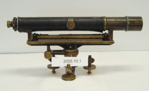
This Dumpy level is engraved “P. & R. Wittstock Level, Berlin. No 865.” Note that the telescope is permanently attached. The only adjustment that can be made is to the horizontal bubble.
Purchased for $250
Level – ALSA 2006.10.01.
Tripod for the level – ALSA 2006.10.02.
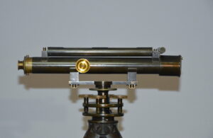
Troughton & Simms 16” Dumpy level. It predates 1922 as in 1922 Troughton & Simms was bought by T. Cooke and Sons of York, England to become Cooke, Troughton & Simms. It was owned by Ray Johnson BCLS and used for levelling for railway construction in the Kootenay B.C. region. The Surveyors’ Historical foundation obtained it from Ken Johnson, Ray Johnson’s son.
Level – SHF 2021.01.01.
Tripod for the level – SHF 2021.01.02.
Cooke, Troughton, and Simms Dumpy Level. s/n S042193.
Donated by the Alberta Director of Surveys in 1999.
Level – ALSA 2006.05.01.
Tripod for the level – ALSA 2006.05.02.
This level was made by Keuffel & Esser Co. New York. s/n 91426. It is a tilting level with a horizontal circle and a partial vertical scale enabling the level telescope to be set on a grade (slope).
Donated by Bob Peverelle
Level – ALSA 2012.05.01.
Tripod for the Level – ALSA 2012.05.04.
Sources of Information:
- Department of the Interior, Annual Report of the Topographical Surveys Branch, 1913-14, page 10.
- Smithsonian National Museum of American History: https://amhistory.si.edu
- Gurley’s Manual – American Engineers’ and Surveyors’ Instruments, 1908
- Survey History, How old is my Gurley: http://www.surveyhistory.org/how_old_is_my_gurley1.htm
Acknowledgement:
Thanks to Ed Titanich, retired from Lands Survey Unit, Alberta Environment and Parks who provided information and access to the 1913-14 Department of the Interior Annual Report.
Author: Gordon Olsson, ALS (Hon. Life)
February, 21, 2022
Copyright 2024 © Alberta Geomatics Historical Society