
10. The Survey Instrument Captain Cook Wanted to Learn – The Plane Table and Alidade
By Gordon Olsson
The plane table and alidade has been used for mapping topographical features for centuries. Don Thomson in Volume 1 of Men and Meridians writes that the first stage of the development of the plane table occurred in Paris in 1551. He recounts a story about Samuel Holland, who became Surveyor General of Canada, instructing Captain Cook in its use. Captain Cook had watched Holland in 1758 mapping Fort Louisbourg the day after its surrender. Holland wrote that Captain Cook had “expressed an ardent desire to be instructed in the use of the plane table (the instrument I was using).”
Plane table mapping is done in the field by graphical methods. A drawing sheet is attached to the surface of the plane table board which is levelled and placed over a control point. Magnetic north can be drawn on the sheet using a trough compass. Objects to be mapped are sighted on by the alidade and lines are drawn on the drawing sheet in the direction of each object. Distances to the objects can be measured by a chain or by stadia. Depending on the area to mapped, the plane table may be moved to another control point and orientated by using the alidade to backsight on the previous control point. By using more than one control point, locations of objects can also be determined by intersection – the intersection of the line drawn at the first control point to the object, and the line drawn at the second control point to the same object will mark its position.
Edouard G. Deville, in the late 1890s, developed the photo-topographical method of mapping which proved superior for mapping large mountainous areas. However, the plane table was still more efficient for mapping smaller areas and its use continued well into the 20th century.
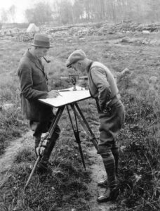
Using a Plane Table in the Field, 1924.
Left on the photo is Bruce W. Waugh, DLS and on the right is Sid Hunt, DLS.
4. ALSA Collection, Weir Album #2, 1 Survey Parties, Sp11.
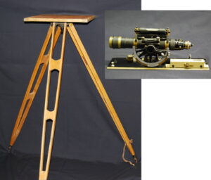
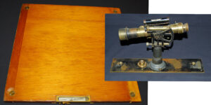
Keuffel & Esser Alidade and Plane Table.
The alidade has stadia lines (two short horizontal lines, one above and one below the horizontal crosshair). The distance from the instrument to a stadia rod is determined by subtracting the bottom stadia reading from the top reading and multiplying the difference by a constant, usually 100. It also had a vertical circle so that the slope of the measurement could be determined for reducing slope distances to the horizontal and also to determine the difference in elevation.
Donated by Lou Breton, ALS (Hon. Life)
Alidade – ALSA 2012.02.01
Plane Table and Tripod – ALSA 2012.02.02
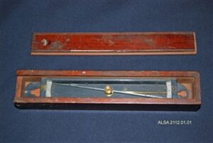
Trough Compass.
It is also called a plane table compass or declinator. It is used to mark magnetic north on the plotting paper on the plane table drawing board.
Donated by Les Frederick, ALS (Ret.)
ALSA 2012.01.01
Plane Table Drawing Board and Bausch & Lomb Alidade.
The drawing board has a compass needle embedded in it so that the board can be oriented with the top pointing north. It comes with a canvas carrying case which is used to transport and store the drawing board. The alidade comes with a wooden case with a trough compass in it. There is a label inside the case marked “Department of the Interior, Topographical Survey of Canada.” The label shows that the alidade was repaired on April 15, 1930.
The drawing board, a tripod for it and the alidade were donated by Steve Cherwonick, ALS#238.
Plane Table Drawing Board – ALSA 2010.06.03
Tripod for the Plane Table Drawing Board – ALSA 2010.06.02
Bausch & Lomb Alidade – ALSA 2010.06.07.
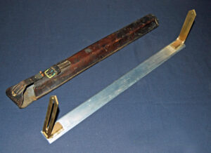
Plane Table Sights
It is marked “T.S. 1964. Made by the Frank Raw Company Ltd Toronto.” Sights such as this could be used for plane table mapping. However, they could not be used to determine distances by stadia or used to determine differences in elevation as it could not be used to measure vertical angles.
Donated by Steve Cherwonick, ALS#238.
ALSA 2010.06.04
Sources of Information:
- Don Thomson Men and Meridians Volume 1,pages 21, 94, and 95.
Author: Gordon Olsson, ALS (Hon. Life)
January 10, 2022
Copyright 2024 © Alberta Geomatics Historical Society