11. Early Geodetic Theodolites were King
By Gordon Olsson
The Geodetic Survey of Canada was officially established in 1909 with William Frederick King as Superintendent, Chief Astronomer, and Boundary Commissioner. He had been involved in geodetic surveys for many years. In 1872 King, then a young 18-year-old sub-assistant astronomer, was part of the Canadian Commission surveying the 49th parallel. In 1876, he became a Dominion Land Surveyor (DLS) and a Dominion Topographical Surveyor (DTS) and then had a distinguished career working for the Department of the Interior where geodetic surveys were required to establish meridians and baselines for the Dominion Lands Survey.
The instruments used to establish the meridians and baselines for the Dominion Lands Survey are discussed in Surveys were to be Astronomical. While the geodetic positions established by the instruments and methods of the day may not in all cases have been close to the true value, they were accurate enough for a survey system where monuments govern. After the Geodetic Survey of Canada was established, geodetic surveys became more sophisticated with geodetic theodolites, invar tapes for measuring baselines, triangulation networks and timber towers being applied. The early theodolites were large and heavy. They had up to twelve-inch diameter micrometer circles and could weigh over 100 pounds.
The theodolites described in this article were probably not used by the Geodetic Survey of Canada after 1927. By then the Wild T2 and Wild T3 were used for triangulation work.
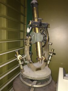
This theodolite was made by Bausch, Lomb, Saegmuller Co. of Rochester, NY. It comes with a stride level which is mounted on the theodolite. Circa 1907 – see the image below in the Bausch, Lomb, Saegmuller Company’s 1907 catalogue.
Donated by the Surveyor General Branch, Natural Resources, Canada.
ALSA 2016.01.09
Stride Level – ALSA 2016.01.10
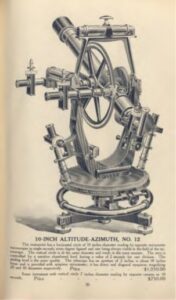
This page, from Bausch, Lomb, Saegmuller Company’s 1907 catalogue: Astronomical and Engineering Instruments, shows a similar instrument to the theodolite and stride level shown above. The Bausch, Lomb, Saegmuller company was only in existence from 1905 to 1907.
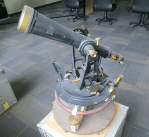
This theodolite was made by E.R. Watts & Son, London. A geodetic theodolite that is similar to it is shown on pages 16 and 17 of an E.R. Watts and Sons Limited catalogue published in 1910. Two models were available, one with a 10” circle, the other with a 12” circle. Both were advertised as reading to one second and being “packed in two strong teak cases for transport.”
Donated by the Surveyor General Branch, Natural Resources, Canada.
ALSA 2016.01.03.
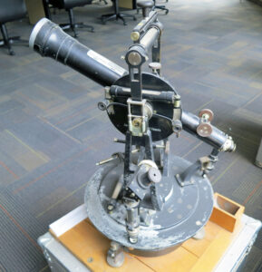
This theodolite was made by Kern & Co. Marked on the body is “Kern & Co, Aarau, Swiss, 1914 No 21135”. On it is a striding level.
Donated by the Surveyor General Branch, Natural Resources, Canada.
ALSA 2016.01.11.
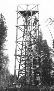
An observation tower used by the Alberta Surveys Branch for survey control in the Alberta foothills. Ilmar Pals ALS#211, who took this photograph, worked on geodetic surveys in Europe and contributed to the implementation of the Alberta Survey Control System. Note that an interior tower was built to hold the survey instruments and a separate exterior tower was used to hold the person doing the observing.
ALSA Collections: 5. Photographs, Historical: 27 Eda (Ilmar Pals): P7 Foothill Survey Tower, 1959-62.
Sources of Information:
- 100 Years of Geodetic Surveys in Canada: https://www.nrcan.gc.ca/maps-tools-publications/maps/100-years-geodetic-surveys-canada/9110.
- Manual Shewing the System of Survey of the Dominion Lands, 2ndEdition 1881, page 57.
- Olsson, Demarcation of the Boundary between Canada and the United States of America from the Lake of the Woods to the Rocky Mountains, December 2016, ALS News.
- Bausch, Lomb, Saegmuller Company’s 1907 catalogue: Astronomical and Engineering Instruments.
- 1910 – E.R. Watts and Sons Limited catalogue: https://archive.org/details/E.R.WATTS1910AllPages/page/n15/mode/2up.
- L. Rannie The Geodetic Survey of Canada, Empire Survey Review, October 1949.
Acknowledgement:
In 2015 Peter Sullivan, Surveyor General of Canada, informed the Collections Group of the Historical & Biographical Committee that the Geodetic Survey of Canada was considering surplusing or donating some old geodetic instruments. The Collections Group made a successful pitch for the instruments to Caroline Huot of the Geodetic Survey of Canada and in early February of 2016 Monroe Kinloch, on his own expense, flew to Ottawa to select instruments that were used for geodetic surveys in Canada. Subsequently the Geodetic Survey shipped the objects to the Association office. Initially they were provided as a long-term loan. Finally, approval was received for an outright transfer which was actualized in June 2016. Several of these instruments are described in this article and in Articles 12. The collection is fortunate to have these instruments – perhaps the best collection, or one of the best, of its kind in Canada.
Author: Gordon Olsson, ALS (Hon. Life)
January 10, 2022
Copyright 2024 © Alberta Geomatics Historical Society
