
15. The “Vagaries of that Instrument” – The Altimeter
By Gordon Olsson
Altimeters measure the height above sea level by measuring barometric pressure. Altimeters and barometers are similar in that they both measure atmospheric pressure; however, an altimeter has additional functionality which allows pressure readings to be converted to altitude. An aneroid altimeter consists of a box or chamber partially exhausted of air, having an elastic top and a pointer to indicate the degree of compression of the top caused by the external air. They had limitations because of changing barometric pressure. Arthur O. Wheeler, in his 1905 book The Selkirk Range, writes about the aneroid altimeter while discussing the variation of observed elevations of mountain peaks in the Selkirk Mountains:
“… it merely emphasizes the vagaries of that instrument, the results of which, without a stationary aneroid working in unison with the travelling one, to permit the elimination of atmospheric changes, are a mere approximation. Aneroids are individually very useful instruments for short distances, provided no lengthy period intervenes between the readings. They were used during the survey with great advantage to ascertain the difference of level between the railway base and the rivers flowing beside it at the valley bottoms; but for extended differences of elevation, without a stationary, they cannot be relied upon, and even using a stationary, it is a matter of great difficulty to obtain two that work together, and constant checking and comparison is required.”
Early electronic distance measuring instruments measured transit times through the atmosphere. The tellurometer measured transit times of radio waves and the geodimeter measured transit times of light beams. Altimeters or barometers were used to obtain the atmospheric pressure which was required to make corrections to the measured distances. The distances also required corrections for temperature and humidity.
In recent times, with global positioning systems, accurate altitudes can be determined without readings being affected by changing weather affecting atmospheric pressure.
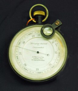
This altimeter is marked “Surveying Aneroid – Compensated” “E. R. Watts & Son London, Eng. Ottawa & Winnipeg.” The inner scale measured barometric pressure and the outer scale height above sea level. The date of production could be in the 1910s. Just after the turn of the century, branches of E.R. Watts & Son were established in Ottawa and Winnipeg. In 1909, the Canadian branches became a separate company called E. R. Watts and Son Ltd. of Ottawa. The Canadian company eventually became part of Instruments Ltd. of Ottawa and Toronto. The 1910 seventh edition of the DLS Manual required that Dominion Land Surveyors conducting township survey work have a “surveying aneroid barometer.” Recordings of estimated heights of “remarkable hills or ridges” above the bottom lands were required if they were crossed by surveyed lines.
Donated by Sid Leoppky, ALS (Hon. Life)
ALSA 2014.02.04
The Alberta Land Surveyors’ Association collection has two other similar surveying altimeters. One was marketed by The Topley Company. It is described in Article 8 of this series “The Topley Company.” It was donated by C.H. Weir, ALS #164. ALSA 2007.27.08
The other was made by Short and Mason, London. Similar Short and Mason altimeters are shown in a 1929 Tycos catalogue (called aneroid barometers in the catalogue). Its source is unknown. ALSA 2007.07.01
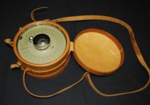
This altimeter is one of an identical pair. It is marked “Micro, Model M-2 made by American Paulin System.” The diameter of the face of the altimeter is 17.5 cm. They were owned by Harold Brown, ALS #156 of H.W. Brown & Company, predecessor of the company Brown Okamura & Associates Ltd. They were used to obtain topographic data for irrigation projects in the Bow River Irrigation District expansion in Southern Alberta in the 1950s.
Dave Williams, ALS (Ret.) describes the process: “To obtain more reliable data than by using the altimeters independently, one altimeter was left on a place of known elevation (the base elevation) with reading taken at set time intervals. In the field, the time was recorded when each elevation was taken with the other altimeter. At the end of each day, the time of the elevation recorded in the field was compared to the reading on the base altimeter so a correction to the field data could be made. Using this method, any change in barometric pressure through the day was compensated for.”
“The elevations obtained by these altimeters were used to prepare contour plans of quarter sections to determine the extent of area that could be irrigated by flood irrigation methods. For areas that could be irrigated more precise data was obtained by spirit levels so the area could be mapped more accurately.”
Donated by Dave Williams, ALS (Ret.)
ALSA 2008.14.01 and ALSA 2008.14.02
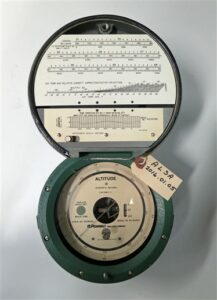
This altimeter is one of a pair. They are marked “Pennwalt” “Wallace & Tiernan” Model NO FA 181000. The Pennwalt Corp. was established in 1969 so the production of these altimeters would be after that date.
From the tables on the altimeter shown above, the Geodetic Survey of Canada would likely have used them for determining altitude and for determining atmospheric pressure for electronic distance measuring corrections.
Donated by the Surveyor General Branch, Natural Resources Canada.
ALSA 2016.01.04 and ALSA 2016.01.05
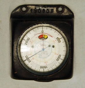
Thommen Everest Altimeter. Monroe Kinloch, ALS (Hon. Life) provided the following information:
Thommen altimeters have been built by Thommen Aircraft Equipment Ltd. since 1916. It is an Everest model and as all their altimeters are marked with a maximum operation limit. The leather case is marked 15,000F at the top. As the name, Thommen Aircraft Equipment Ltd. indicates, they are still a major manufacturer of aircraft gauges worldwide. They have produced these pocket-sized altimeters for many years for the use of adventurers, mountain climbers, and surveyors. They are well made, rugged, and easy to use with instruction manuals. “J. Bruce Underwood, SLS, ALS #167 used it for the survey of a control network on and around Grande Mountain for the coal mining operations near what later became the new town of Grand Cache. Unfortunately, during the survey of the network, Mr. Underwood was involved in a vehicle rollover on a mountain trail in 1973, sustaining injuries that led to his death in June 1974.”
This altimeter was acquired by Kinloch Underwood & Associates Ltd. of Edmonton, AB through the purchase of assets and equipment from the previous survey firm, J.B. Underwood and Associates Ltd. of Edmonton, AB in 1974.
Donated by Monroe Kinloch ALS (Hon. Life)
ALSA 2008.02.09
Sources of Information:
- A.O. Wheeler, The Selkirk Range, 1905, page 312.
- D. Stretton, From Compass to Satellite, Published in the Canadian Surveyor, Dec 1982, Vol 36. No. 4.
- R. Watts & Son 1910 Catalogue, Canadian Branches,
- 1910 7th Edition DLS Manual, page 60, s.205(f) and page 104, s.289.
- 1929 Catalogue, Tycos Meteorological and Other Scientific Instruments, pages 44 and 45.
Author: Gordon Olsson, ALS (Hon. Life)
February 10, 2022
Copyright 2024 © Alberta Geomatics Historical Society