
23. Pain or Panacea – Chains to Feet to Metres
By Gordon Olsson
Land surveyors in Canada for decades before the 1970s had been used to working in two units of measurement, the chain and the foot. A 1970 Canadian decision to adopt the metric system added one more – the metre. After the 1970 decision, land survey associations and government survey departments all across Canada established committees to determine the effect on their organizations, to make recommendations for change and to plan for implementation. The Alberta Land Surveyors’ Association was no exception. In the early 1970s it established a special committee on metric conversion that carried on for several years. One of its functions was to draft a set of guidelines for metric conversion to be submitted to the Director of Surveys and to the Land Titles Office. By the end of the decade, these government departments and the Alberta Land Surveyors’ Association itself required that distances on survey plans be in metres, that areas be in hectares, and that natural scales (such as 1:1000, 1:2000, 1:5000) be used.
What didn’t change? Sections remained 80 chains (one mile) square and road allowances remained one chain (66 feet) wide, despite a news report in a Red Deer paper that the conversion to the metric system would require that all the road allowances in the province be moved so sections could be one kilometre square. The year of the news report has been forgotten but the month and day is recalled as April 1.
Was the metric system a panacea for surveyors? Not exactly. Before metrification there was already a potpourri of plans, some with distances in links and chains, others in feet and decimals. The same with plan scales, with scales such as 1 inch = 1 chain, 1 inch = 100 feet, and some even in natural scales. The metric system added one more unit of measurement to contend with and land surveyors (with one foot in the past and one in the present) had to convert from one unit to another.
From the time of the initial surveys in Alberta, an astonishing number of different types of measuring tapes were produced. In 1870 for certain Dominion Lands surveys, lines were to be initially measured in chains and check-chained in feet. As a result, for convenience, steel band tapes were produced that were calibrated in links and chains on one side and feet on the other. After the metric system was adopted, similar steel band tapes where produced that were calibrated in feet on one side and metres on the other. The metric system was used in parts of Europe in the early days so metric tapes were available before the system was adopted in Canada. Arthur O. Wheeler wrote that a 1/8 inch wide, hundred-metre long tape was used to measure base lines during his photo-topographical surveys in the Selkirks in 1901 and 1902.
The Alberta Geomatics Historical Society collection has several steel band tapes, a few of which are illustrated below. Steel band tapes when introduced were commonly called chains and that term is still commonly used today as is the term chaining still used to describe the process of measuring.
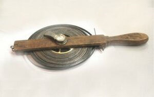
Links and chains.
This tape is three chains long. It is marked “THE LUFKIN RULE CO. CANADA LTD” and “NRL 1609.” The metal reel is marked “LUFKIN MADE IN USA.”
The Lufkin Rule Company in 1890 introduced the first steel measuring tape produced in the United States. The Lufkin Rule Company and the Chesterman Company dominated the manufacture of surveyor’s tapes used in Canada. A similar looking tape is in a 1907, Bausch, Lomb, Saegmuller Co. catalogue.
This tape was part of a collection of monuments and survey artifacts belonging to C.H. Weir ALS#164.
Donated by Steve Dixon, WSP Geomatics.
ALSA 2018.01.10
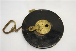
Links on one side and feet on the other.
This tape is one chain long. It is calibrated in links on one side and in feet on the other. It is marked “Chesterman Sheffield, England.” The reel of the tape is marked “No 1650 Patent, Chesterman Sheffield, England.”
Chesterman is one of the companies that dominated the manufacture of surveyor’s tapes used in Canada. The Company was founded in 1827 in England.
It is believed to have been owned by A.G .Stewart ALS#078.
Donated by C.H. Weir ALS#164.
ALSA 2007.27.01
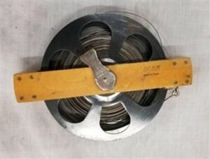
100-foot tape
This steel tape is marked “100 FT PATENTED AUG 18, 1903.” It is broken at the 85-foot mark. It is very similar to a tape shown in a 1910 E.R. Watts & Son catalogue. The tape belonged to Reginald Hutton Cautley ALS#005. It was purchased from the estate of Elizabeth Cautley in 1991. Elizabeth was the wife of Charles Forsyth Cautley who was the only son of Reginald Hutton Cautley and his wife Marjorie. Reginald was the brother of Richard Cautley ALS#006.
Estate of Elizabeth Cautley
ALSA 2006.02.01
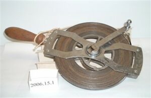
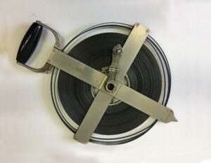
100-foot tape
This steel tape is calibrated in feet and tenths of a foot throughout. It is marked “TENTHS STANDARD AT 20C WITH 15 LBS PULL.” Identical looking tapes are shown in a 1951 Instruments Limited catalogue. They came in lengths of 100, 200 and 300 feet. They were very durable and along with similar Keuffel & Esser tapes, were standard equipment for survey parties at the time and for many years after.
Donated by Al Edwards, ALS#224.
ALSA 2006.15.01
 Metres on one side and feet on the other.
The metric side of this 100 metre tape is marked “METRE” and is calibrated in metres and centimeters.The foot side is marked “ENGLISH THE LUFIN RULE Co. OF CANADA LIMITED” and is calibrated in feet and hundreds of a foot.
The reel is marked “LUFKIN RULE Co. OF CANADA LTD. WINDSOR, ONT.”
It belonged to Reg J. Watson ALS#225.
Reg Watson Estate
SHF 2015.01.21
Sources of Information:
- December 31, 1879, Memorandum to accompany Instructions for the Survey of Standard Meridians and Parallels forming the outline of Blocks of Sixteen Townships of the Dominion Lands Survey).
- The Canadian Surveyor: June 73, December 73, March 1977,
- ALS News: Summer 1975, Summer 1978,
- Wheeler, A.O. The Selkirk Range, British Columbia, 1905. page 46.
- 1907, Bausch, Lomb, Saegmuller Co. catalogue, page 97.
- 1951 Instruments Limited catalogue, pages 263 to 267.
Author: Gordon Olsson, ALS (Hon. Life)
May 31, 2022
Copyright 2024 © Alberta Geomatics Historical Society