

30. Mainframe Computing in the 1960s and 1970s
By Gordon Olsson
In 1969, the Canadian Institute of Surveying Control Survey Committee solicited several federal, provincial and municipal government survey departments, university survey departments, and computer companies for a description of computer programs which was to be published in the Canadian Surveyor so others could benefit by sharing knowledge. C.W. Youngs, Alberta Director of Surveys, responded with programs for Geodimeter and Tellurometer MA100 distance reduction and management of coordinates for automated coordinate plotting. As time went by, programs were developed for more sophisticated calculations such as coordinate geometry and least square adjustments. Nearly all the programs were written in Fortran, a program for scientific and engineering applications, and they ran on large main frame computers such as the IBM 360 and CDC 3100.
By 1970, mainframe computing was well established in several federal, provincial and municipal government survey departments. It was economical for government survey departments as mainframe computers could be shared by several government departments. Also, a private Ontario company, ProCouncil Computer Services Ltd. provided mainframe computer applications for the survey profession.
Mainframe computing enabled adjusting large survey networks such as those for large subdivisions. The survey data was written on paper forms and then an operator would enter the data on punched cards using a keypunch keyboard. The resulting deck of cards were then fed into the computer. A later advancement was punched paper tape where data could be stored on one roll of tape instead of hundreds of punched cards. Inevitably, the results contained errors and the erroneous data had to be corrected and the program run again, often several times. The work was time consuming but effective.
One private company in Alberta that developed their own coordinate geometry program was Coordinate Surveys Ltd. The account written below by Norm Mattson, ALS (Hon.Life) outlines the companies experience in developing the program to be run on mainframe computers.
LASUR (Land Surveyors Program)
Coordinate Surveys Ltd. was incorporated in May, 1969 by Marlin Sexauer ALS, Hans Nederveen, ALS and Norm Mattson, ALS and they began offering professional survey services to clients situated in the Edmonton region. Some of their major projects involved the provision of legal and construction surveys for the creation of the New Town of Grande Cache and for new residential subdivisions being developed by BACM Limited, one of the first private residential developers in Edmonton. This entailed performing an enormous amount of computations that were done on a rented LGP30 computer in Calgary, on an electronic Olivetti computer that utilized magnetic strip cards for specific types of computations and on smaller mechanical calculators. It soon became apparent that a better and more efficient coordinate geometry program was needed to handle the vast amount of data being generated.
In 1970, Dr. John Duby, B.Sc., B.A., D.Phil., P. Eng., who was a former fellow employee with Marlin at Associated Engineering Services Ltd., was retained ( coerced is probably a better word) to write a new coordinate geometry program that was to be designed specifically for Land Surveyors to perform their day to day computations. At the same time, Jack Hill, ALS of Control Land Surveys Ltd. was also encountering the same type of logistical problems and he came on board as a full partner to offer technical suggestions and beta test the new program with Norm Mattson as it evolved.
LASUR is a very rudimentary program compared to the sophisticated programs that are currently used by the Land Surveying community, but it was a big step forward during the early 1970’s. At that time, there was no commercial computer outside of the University of Alberta that could handle the size of the LASUR program and the associated data files. As a consequence, the partners negotiated the use of a dedicated telephone service line with AGT and used teletype terminals to send and receive data to a computer owned by General Electric and situated in Los Angeles, California. Batch computations were prepared in Edmonton, transmitted to LA and then returned with the results. At times, this proved to be very tedious work because of the inevitable input errors and this sometimes caused data to be processed 2 or 3 times. However, it was still much more efficient and cost effective than most other coordinate geometry programs being utilized at that time.
In the mid to late 1970’s, Wang began offering a similar coordinate geometry program that could be used on an in-house computer that was also tied into a flat bed plotter. This was a very important advancement because of the new plotting capability, but their coordinate geometry program was still inferior to what LASUR offered. Jack Hill and Norm visited Hector Holguin, President of Holguin and Associates in El Paso, Texas, who developed the program to run on the Wang computer, with the intent of negotiating with Hector to combine the two programs into one efficient one for use by the land surveying community in North America. In the end, we were not successful to the extent that we would get rich from any type of royalty arrangement, but a significant number of LASUR routines were ultimately incorporated into the Holguin program.
The original LASUR program experienced a slow death and was abandoned sometime around 1980.
Norm Mattson
August, 2010
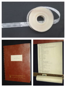
LASUR (Land Surveyor’s Program). At the top is a 13.5cm diameter, 2.5 cm wide punch tape, The bottom left is of the manual for the program dated 1975. At the bottom right is a printout of the program written in Fortran.
Donated by Norm Mattson ALS (Hon. Life)
ALSA 2011.05.01
Sources of Information:
A selective List of Computer Programs for Surveyors, The Canadian Surveyor, Supplement, December 1970. p.597.
- Wikipedia, Fortran
- D. Barnes Ltd. Our Story: http://www.jdbarnes.com/our-story.html
Acknowledgment:
Thanks to Norm Mattson ALS (Hon Life) for his contribution to this article.
Author: Gordon Olsson, ALS (Hon. Life)
October 22, 2022
Copyright 2024 © Alberta Geomatics Historical Society