
33. The Skill of Chaining Would Be Lost – The Tellurometer
By Gordon Olsson
The introduction of electronic distance measuring (EDM) in the late 1950s was the start of a rapid evolution in technology that would greatly affect land surveying in the years to come. The Tellurometer, along with the Geodimeter (to be dealt with in the next article), were early leaders in this new distance measuring technology.
The Tellurometer originated in South Africa where Trevor Wadley designed, built and measured distances with a prototype. A production facility was set up in Cape Town and from 1955 to 1957 Tellurometer (PTY) Limited established a distribution network in Ottawa, New York and Melbourne. Around 1967 Tellurometer became a part of the Plessy Group, a large British electronics firm.
The Geodetic Survey of Canada was the first organization in the world to purchase a Tellurometer, initially purchasing the first six MRA1s around 1957. The Alberta Director of Surveys office was also quick to use this new technology. A 1959 picture in the AGHS Historical Photo Collection shows Carl Lester, Director of Surveys, testing a Tellurometer MRA1 (See Article 29: 1960s to 2000s – Surveying undergoes Profound Change). It would not be long before it was standard practice to use Tellurometers to measure lines for triangulation surveys in Canada.
The name Tellurometer MRA is derived from: Tellus = Greek for Earth; Meter = measure; M = Master; R = Remote; A = Ancillary equipment. Hence Tellurometer MRA.
While geodetic, topographic and hydrographic surveyors were quick to adopt the new technology, cadastral surveyors were not. They were expensive and most distances to be measured for cadastral surveys were relatively short. Old-time surveyors lamented that the skill of chaining would be lost, and that survey parties would become ineffective if the instrument quit functioning. Also, many thought that courses in electrical engineering would need to be added to survey education curriculums.
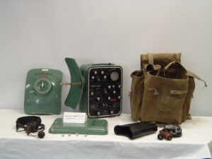
Tellurometer MRA1. The MRA1 was the first Tellurometer commercially available. It was introduced in 1957 and had a normal range of 30 – 50 kilometres. Two units were used; one was the master, and the other was the remote. The master unit emitted a microwave that was received by the remote and the signal was returned to the master. The air temperature, air pressure and relative humidity had to be measured to obtain the refractive index correction. The readout was in nanoseconds which had to be multiplied by the speed of radio waves and which was corrected by the refractive index of air to obtain the distance. This MRA1 (Remote unit) was used by the office of the Alberta Director of Surveys. The ALSA also has a MRA1 donated by the Surveyor General Branch, Natural Resources Canada (ALSA 2016.01.02)
Donated by the Director of Surveys
ALSA 2006.05.05
Tellurometer MRA 2. The MRA 2 was introduced in 1960. It incorporated both the Master function and the Remote function in one instrument. The dual function ability produced the benefits of being able to observe the readout from either instrument. The one in the image is one of five units donated by Carlson Surveys.
ALSA 2007.12.01 to ALSA 2007.12.05
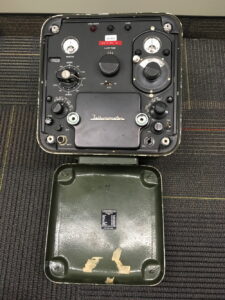
Tellurometer MRA3. The MRA3 was introduced in 1963. It used transistors and had an improved accuracy of +/- 15mm + 3ppm.
A set of two donated by Hamilton & Olsen
ALSA 2015.04.03
ALSA 2015.04.04
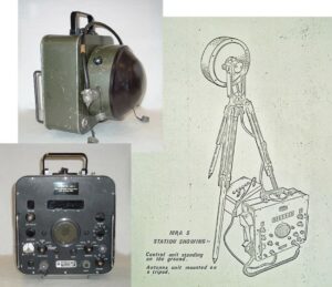
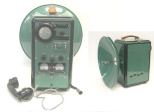
Tellurometer MRA5. The MRA5 was introduced in 1973. The antenna on it could be separated and placed up to 25 metres from the control unit. As a result, it could be placed on a mast high above the control unit to give a line of sight over ground obstacles. The image on the right above copied from the operator’s manual shows the antenna separated from the control unit and a car battery to provide power to the unit.
A set of two donated by the Alberta Director of Surveys
ALSA 2006.05.03.1
ALSA 2006.05.03.2
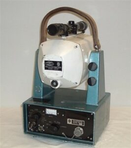
Tellurometer MA100. The MA100 was introduced in 1968. It had an accuracy of +/-1.5mm +2ppm and a range of two kilometres. Only one unit was required as a reflector was used to return the infrared beam.
Donated by the Alberta Director of Surveys
ALSA 2006.05.07
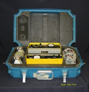
Tellurometer CA1000. The CA1000 was introduced in 1971. It was lightweight, portable and simple to operate. The accuracy was .005 ft +/- 1:100,000 with a range from 100 feet to 25 miles. It could run on flashlight cells or any 12-volt source. The time to take a measurement was only about three minutes. The cost was about $4,000. This EDM was used by Brown Okamura and Associates, Ltd. on the Alberta Survey Control Network in the Crowsnest Pass in the mid-1970s. They were used in pairs comprising a master and a remote.
A set of two donated by Dave Williams ALS (Ret.)
ALSA 2008.14.03
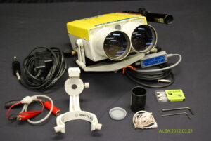
Tellurometer CD6. The CD6 was developed in 1973. It was a small, lightweight infra-red instrument operating over distances up to two kilometres with an accuracy of +/-5mm +2ppm. Signal reflection was from a reflector, so a remote instrument was not required. It could be used by itself, mounted on a tripod or mounted on top of a theodolite.
Donated by Monroe Kinloch ALS (Hon. Life)
ALSA 2008.03.21
Sources of Information:
- Brian Sturman and Alan Wright, The History of Tellurometer, 2008, FIG Working Week, Stockholm, Sweden: https://www.fig.net/resources/proceedings/fig_proceedings/fig2008/papers/hs01/hs01_03_sturman_wright_2833.pdf
- 100 Years of Geodetic Surveys in Canada, https://www.nrcan.gc.ca/maps-tools-publications/maps/100-years-geodetic-surveys-canada/9110
- National Museum of American History, MRA1: https://americanhistory.si.edu/collections/search/object/nmah_759173
- National Museum of American History, CA1000 https://americanhistory.si.edu/collections/search/object/nmah_748795
- The Canadian Surveyor: December 1965, pages 410-414, December 1971, page v and December 1974, page v.
Author: Gordon Olsson, ALS (Hon. Life)
December 3, 2022
Copyright 2024 © Alberta Geomatics Historical Society
The Tellurometer: The Alberta Experience
In response (to the article on the Tellurometer), you might be interested that Dave Usher of Usher and associates was the first private company in Alberta and maybe Canada to purchase and introduce the MRA 1 to survey. I was one of his party chiefs at the time articling under him and became his main operator of the Tellurometers.
People were skeptical of the results at the time, and we had to demonstrate that they were good. I remember specifically demonstrating them to the Director of Surveys office before they bought some themselves. We also used them extensively in North-Eastern BC along the Alaska highway for setting up control for seismic crews. At the time the only survey control was on the peaks of some of the mountains and we would transfer it from there to the valley’s using the tellurometers for distances. It was a bit tricky interpreting the readouts but with practice it came rather naturally. They were powered by six-volt car batteries which were as about as heavy to cart around as the interments themselves. Not to mention the possibility of getting acid on your clothing.
Bill Dabbs, ALS (Hon. Life)