34. Measuring by Speed of Light – The Geodimeter
By Gordon Olsson
The Geodimeter applied the speed of light to measure distances. By measuring the time required for a beam of light to travel to a reflective prism and back it could accurately determine the distance between the two points. As with the Tellurometer, the refractive index correction was applied to the distance requiring air temperature, air pressure and relative humidity to be measured.
Development of the Geodimeter occurred in Sweden in the 1940s with the principal mover in its development being Dr. Erik Bergstrand. Dr. Bergstrand took his concept to AGA who built a prototype in 1951. The first commercial model, the NASM-1, was produced in 1953 with production limited to ten units. It was heavy, weighing around 100 kilograms. Several models followed, with the Model 6, introduced in 1964, being the first model that had widespread acceptance. It was used by the Geodetic Survey of Canada on municipal control surveys from 1968 to 1971. After the Model 6, development continued as new models were designed to be mounted on a theodolite and eventually evolving into total stations.
The name AGA Geodimeter disappeared in 1973 when Geotronics, an independent company within the AGA-group, took responsibility for measuring instruments. Eventually, Geotronics was acquired by Spectra Geospatial, a subsidiary of Trimble Inc. Over the years, the name Geodimeter has disappeared from the product line. Spectra Geospatial develops and markets GPS systems and survey instruments under brand names which include GPS and GIS systems, surveying software, and total stations, theodolites, and levels.
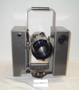
Geodimeter Model 6. The Model 6 was first marketed in 1964. It was fully transistorized, had lower weight than previous models and had less power consumption using lightweight rechargeable batteries. It also had increased range. With a tungsten lamp light source, the Model 6 had a range of about seven kilometres and, with a mercury vapor lamp, it had a range of about twenty kilometres. To be able to measure these distances the measurements had to be taken at night, which may have been a factor in the Tellurometer being more widely used by land surveyors.
Donated by Underwood and Associates Ltd.
ALSA 2006.24.01
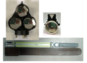
Ancillary equipment for Geodimeter measurements. AGA prisms were used to return the light beam back to the Geodimeter. A whirling (or sling) psychrometer was used to obtain relative humidly. The relative humidity along with the air temperature and air pressure had to be measured to obtain the refractive index correction to be applied to the distance obtained by the Geodimeter.
Triple Prism donated by Jack (Bev) Cheetham, ALS#45.1
ALSA 2016.04.09
Single Prism donated by the estate of Reg Watson, ALS #255
SHF 2015.01.12
Whirling Psychrometer donated by the Surveyor General Branch, Natural Resources Canada
ALSA 2016.01.08
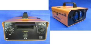
Geodimeter Model 112. The Model 112 was marketed in 1979. It was designed for traversing, setting out and data collection. It could be either telescope or yoke mounted. It had a range of 5.5 kilometres with eight prisms.
Donated by Don George, ALS (Hon Life)
ALSA 2008.09.02
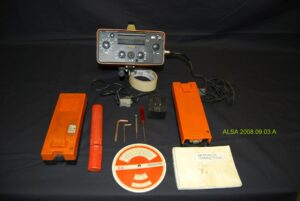
Geodimeter Model 116. It was first marketed in 1979. The Model 116 was designed for the construction market with instantaneous read-out of horizontal distance, difference in height and slope distance. Besides the Geodimeter the image shows two batteries, a psychrometer in an orange case, a wall charger, adjusting tools, a circular scale used to obtain the refractive index, and the operating manual. It was purchased by the ALSA and used by Bill Wolley-Dod, ALS #175, ALSA Inspector of Surveys, and his assistant, technologist Paul Methuen, in the late 1980s and early 1990s.
ALSA 2008.09.03
Sources of Information
- R. Smith “The History of Geodimeter, 1947-1997, http://www.geotronics.it/public/geodimeter_story.pdf
- James Smith Murphy, Electronics Based Innovation in a Niche Market: Distances Measured By The Speed Of Light, Thesis submitted to the Graduate Faculty of North Carolina State University. 2004: https://repository.lib.ncsu.edu/bitstream/handle/1840.16/961/etd.pdf?sequence=1
- 100 Years of Geodetic Surveys in Canada. https://www.nrcan.gc.ca/maps-tools-publications/maps/100-years-geodetic-surveys-canada/9110
- Spectra Geospatial, About Us: https://spectrageospatial.com/about-us/
- The Canadian Surveyor, Annual Report 1965 (Model 6), page ii,
Author: Gordon Olsson, ALS (Hon. Life)
December 8, 2022
Copyright 2024 © Alberta Geomatics Historical Society
