

37. More than a Technological Change – GPS
By Gordon Olsson
One would not get much of an argument if they stated that global navigation and positioning by satellite was the most significant development in history affecting navigation and surveying. However, for surveying it was more than a change in technology. It resulted in a transition from determining position in relationship to nearby objects to determining position in relationship to worldwide spatial reference systems facilitating hundreds of applications.
The first satellite navigation system was the US Navy Navigation Satellite System (commonly known as Transit). It was available for civilian use by 1967. Other systems include the Russian GLONASS system, which was formally declared operational in 1993, European Union’s Galileo, China’s BDS, India’s NAVIC and Japan’s QZSS. Transit operated for 28 years until 1996, when it was officially replaced by the current Global Positioning System (GPS). GPS was available in the early 1980s, but with a limited number of satellites. GPS is currently maintained and operated by the United States Space Force and is the most widely used of the several other global navigation and positioning satellite systems.
The surveying and mapping community was one of the first to realize the advantages of GPS. It did not require line-of-sight visibility between survey stations. It could operate anywhere where there was a good view of the sky, less than ideal weather conditions, and by using the right equipment and methodology, high accuracies could be obtained. Calgary-based Nortech was a world leader in GPS positioning and navigation. The company was founded by Shell Canada. In 1983 it sold the assets to a group that formed Nortech. Alex Hittel ALS, DLS and P. Eng. was its president and chair of the board. Alex also served as president of the Alberta Land Surveyors’ Association in 1977–78 and 1998–99.
One of the first cadastral survey companies in Alberta to utilize GPS was W.D. Usher & Associates Ltd. In an advertisement in the 1986 Canadian Surveyor Usher states that they had been developing an expertise with GPS since 1983 and had acquired four Wild Magnavox WM101 GPS Satellite Surveying Systems. The ad stated that the WM101 provided “single point positioning accuracies to within five metres and differential accuracies of +/- 10mm +/- 2ppm; both with less than an hour observing time.“ Hal Janes, ALS who worked for Usher had this to say about early GPS surveys: “Usher performed two GPS surveys for the Alberta Bureau of Surveying and Mapping in 1984 & 1985 that involved the location and coordination of hundreds of township corners in a band centered on the Slave Lake/Athabasca/McMurray region. I think these were the first two cadastral tie projects in the province. Most of the sites were helicopter access only, and the Macrometer receivers used were so large they had to be modified to fit in the back of the Bell 206 helicopters used for the surveys. There were only four satellites operational at the time and these were only visible for brief windows, so careful logistical planning was paramount to success. Each position required hours of post-processing.”
Global navigation and positioning by satellite were significant parts of the “digital revolution” (there are other terms: the “scientific-technical revolution,” the “information age,” and the “third industrial age”). No longer was it adequate for boundary monuments to be only referenced to adjoining monuments or to small local coordinate survey areas – their location (as well as other land related information) needed to be related to official spatial reference systems, which, enabled the information to be used by geographic information systems that were proliferating around the world.
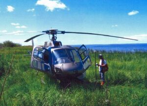
Maltais Geomatics was also a pioneer in applying GPS to cadastral surveying. The image above shows the survey of the natural boundary of Chipewyan first Nation Reserve 201 by Maltais Geomatics on the Athabasca River Delta using RTK GPS in 2006.
ALSA Historical Photo Collection: 19. Maltais 2008-10-14
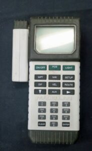
Magellan GPS NAV 5000 PRO. This GPS receiver was described in its 1991 user guide as an affordable, handheld GPS receiver that is fast, powerful and accurate, yet easy to use. The 153 page user guide stated that an accuracy of 25 metres or better is typical. It was 12.7 cm x 22.2 cm x 5.1 cm and required two AA alkaline batteries. The Magellan Corporation was founded in 1986. It introduced the NAV 1000 in 1988 which was the first hand-held receiver introduced to the consumer market. The NAV 5000 PRO followed a few years later.
Donated by Jim Pinchas
ALSA 2022.02.02
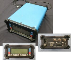
GPS Ashtech X11. The ALSA collection includes an Ashtech X11 receiver, antenna, cables, a measuring stick for measuring the height of the antenna and several manuals dated from 1993 to 1994. A second Ashtech X11 receiver used for differential positioning), an antenna and cables for it are also included, along with rechargeable batteries for both units. Shown above is the main unit GPS receiver.
Ashtech was founded in 1987 in California. In 1997 Ashtech Corporation merged with Magellan Systems and became the Magellan Corporation. After name changes and changes in ownership the company was sold to Trimble in 2011 and is now part of Spectra Precision.
Donated by Jim Pinchas
Main Unit: ALSA 2022.02.03
Second Unit: ALSA 2022.02.04
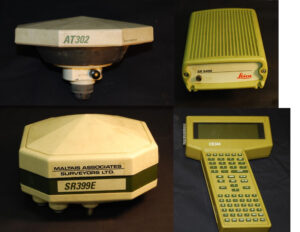
Leica Surveying System 300. The above image shows components of the Leica Surveying System 300. Leica introduced the system in 1994. The main components include: a GPS receiver, a sensor and a controller. The receiver is set up over the control point. The sensor receives the satellite signals from the receiver. The controller controls the sensor, logs the data and manages the survey operation. The “E” designation in the SR399E receiver means that it also had an external antenna which is shown in the image above.
The Leica Surveying System 300 was produced by the Leica Group. Although the Leica Group was established in 1990, its history goes back 200 years as it was formed from amalgamations of the Wild Heerbrugg, Leitz and Kern companies. In 1997 the Leica Group split into two companies Leica Microsystems and Leica Geosystems. Leica Geosystems today is a leader in producing surveying instruments.
Several Leica Surveying System 300 units were donated by Maltais Geomatics. Receiver SR399E: ALSA 2010.12.03
Sensor SR9400: ALSA 2010.12.07
Controller CR344: ALSA 2010.12.10
External Antenna AT302: ALSA 2010.12.06
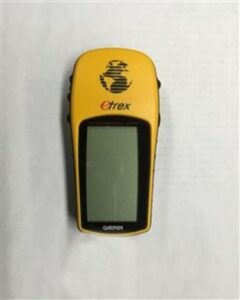
Garmin GPS, model etrex. It used single point positioning with the unit containing the antenna, receiver and processing software. Handheld GPS units are useful in surveying for finding the general location of monuments and route finding.
The Garmin company was formed in 1990. Today it specializes in GPS products for fitness, recreation, aviation, marine and automobile use.
This unit was used by the ALSA for survey inspections.
ALSA 2011.07.03
Sources of Information:
- US government information about GPS: GPS: The Global Positioning System
- Aerospace: Brief History of GPS, The Aerospace Corporation
- National Museum of American History: https://americanhistory.si.edu/collections/search/object/nmah_1405613
- Leica Geosystems: https://leica-geosystems.com/about-us/summary/history
- Geoconnect, Ashtech History: https://geoconnect.com.au/ashtech-history/
- Virtual Archive of Wild Heerbrugg: Wild GPS System 200-300 (wild-heerbrugg.shop)
- Garmin, 2021 Annual Report: https://www8.garmin.com/aboutGarmin/invRelations/reports/2021_Annual_Report.pdf
- The Canadian Surveyor: Autumn 1984, page 177-192; Spring 1986, page I.
- Geomatica: 1995 (2) page 243 and inside back cover: 2017 (1) pages 61 and 62.
Acknowledgement:
Thanks to Hal Janes ALS (Retired) who contributed to this article.
Author: Gordon Olsson, ALS (Hon. Life)
April 18, 2023
Copyright 2024 © Alberta Geomatics Historical Society