
04. Manuals of Instruction for the Dominion Lands Survey
By Gordon Olsson
In 1871, the survey of public lands commenced in what was then called Manitoba and the North-West Territories. A description of the system of survey, and instructions for field surveyors conducting the surveys were provided in several editions of manuals of instruction that were published over the years. The first edition, issued in 1871 by J.S. Dennis, Surveyor General, was titled “Manual shewing the System of Survey adopted for the Public Lands of Canada in Manitoba and the North-West Territories with Instructions to Surveyors, Illustrated by Diagrams.” The 1872 Dominion Lands Act designated lands in Manitoba and the North-West Territories as Dominion Lands. After that date the term “public lands” was replaced with “Dominion lands” in subsequent manuals.
Several Alberta Land Surveyors have donated early Dominion Lands Survey manuals to the ALSA historical survey artifact collection. These are located in the Alberta Land Surveyors’ Association library. The donations also include Maps and Specimen Plans to accompany the Manuals, and Supplements to the Manual of Instructions (The supplements include tables required for the survey of the Dominion lands). Names of a few of the owners of the manuals, in addition to those illustrated below, are Charles Snell ALS#122, Jack Holloway ALS#134, George Palsen ALS#141, Charlie Weir ALS#164, Wally Youngs ALS#191, and Michael Tarczynski ALS#243.
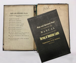
Maps and Specimen Plans to Accompany the Manual of Instruction for the Survey of Dominion Lands. Owned by D.T. Townsend ALS#58
Donated by Al Jamieson
ALSA 2015.03.02
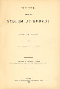
The oldest Dominion Lands Survey Manual that the ALSA has is the 1881 second edition. It was owned by William Pearce, ALS#031. Pearce was amongst the first Dominion Land Surveyors who went west to survey the Dominion Lands Survey. He was an assertive bureaucrat, who played a major role in the development of the west. He became known as the “Czar of the West” and is reported to have had “the ears of John A Macdonald.” He was the Alberta Land Surveyors’ Association’s first president and was awarded its first life membership.
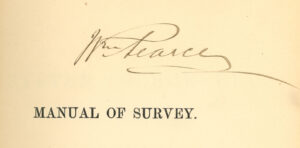
The image above shows the title page of William Pearce’s 1881 Dominion Lands Survey Manual, and below his original signature on one of the front pages. The manual was owned by R. McCutcheon, ALS#139 before it was donated to the ALSA.
ALSA Library: M 902
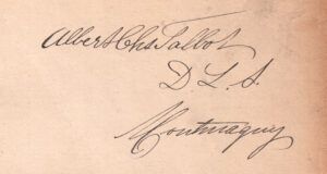
Another notable manual in the collection is an 1883 third edition “Manual shewing the System of Survey of the Dominion Lands with Instructions to Surveyors.” On the first page it has the signature “Albert Chs Talbot D.L.S. Montmagny.” “Chs” is Charles abbreviated. He received his commission as a Dominion Land Surveyor in 1877 and was engaged in surveys in the North-West Territory. From 1902 to 1925, he was Examiner of Surveys for Alberta. He was a charter member of the Alberta Land Surveyors’ Association and president in 1915. Similar to William Pearce’s 1881 manual, this manual also was owned by R. McCutcheon before it was donated to the ALSA.
ALSA Library – M910.
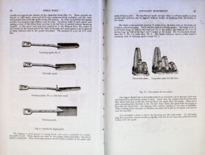
Pages 26 and 27 of the 1905 fifth edition of the
Manual of Instructions for the Survey of Dominion Lands
The old DLS manuals gave very detailed procedures for chaining, measuring angles, recording observations and placing monuments. For example, page 26 of the 1905 sixth edition has diagrams showing four types of spades to be used for digging pits. In the text that followed on the next page, the specific application of each type of spade is described. The text goes on to say, “the diggers should have a shoe plate made of 3/16 steel plate cut to the size of his shoe and fastened to the foot by straps or laces.” and “when walking from one point to another, the steel sole is tied to the spade and carried over the shoulder.” While such detail may seem unnecessary today, at that time, it was probably quite useful to a novice field party. Later, particularly as technology rapidly changed, instructions for surveys focused more on the end result with the methodology left up to the individual surveyor.
Ten editions of the DLS Manual were published between the dates of 1871 to 1946, along with various amendments and supplements. If anyone is interested in accessing these manuals, they are available on the Surveyor General of Canada Lands website.
Later articles in this series will touch on the instrument requirements in the various Dominion Lands Survey manuals and changes to them over the years.
Sources of Information:
- ALSA Website: Alberta Land Surveyor’s Association History. A.C. Talbot, William Pearce.
- Surveyor General of Canada Lands Website: National Standards / Historical Publications / Dominion Lands manuals – 1stto 10th Editions (1871-1961)
Author: Gordon Olsson, ALS (Hon. Life)
October 2, 2021
Copyright 2024 © Alberta Geomatics Historical Society