

06. The Gunter’s Chain is Replaced by the Steel Band Chain
By Gordon Olsson
When the first township surveys in Western Canada were carried out, the Gunter’s chain was used. The 1871 First Edition of the Manual Shewing the System of Survey adopted for the Public Lands of Canada stated: “All measurements will be made with the ordinary four pole chain,” The term four pole chain is synonymous with the term Gunter’s chain. Later editions used the term Gunter’s chain in the same context.
William Ogilvie in 1912 gave an interesting account of the deficiencies of the Gunter’s Chain and its replacement, the steel band chain:
“Many of us can recall the old-fashioned wire link chain with its everlasting change of length through the wear of the links upon each other. Usually, the best makes had three short links and a long one to every link of measure, this made four hundred links and eight hundred surfaces wearing upon each other while the chain was in use. It is not surprising therefore, that as a measure it required almost daily adjustment. I became so dissatisfied with mine in my local practice around Ottawa that I devised a new form of chain and wrote to Chesterman of Sheffield, England describing my idea, and telling something of the unreliability of the old form. In due time I received a reply thanking me for my consideration in placing the matter before the firm, as I had, and further stating that if I had seen their new form of steel band chain, they did not think I would have written as I had and invited me to order one through their agent here, Mr. James Hope. This I promptly did and in September 1879 received my first steel band chain, which I may say, I have used a great deal, and it is still in existence, good for more use.”
On December 31, 1879, a “Memorandum to accompany Instructions for the Survey of Standard Meridians and Parallels forming the outline of Blocks of Sixteen Townships” was issued. In this memorandum, steel band chains replaced the Gunter’s chain. Two sets of Chesterman continuous steel band chains were to be used. The first, 66 feet long (the standard length of a Gunter’s chain) was used for the initial measurements tying in topographical information and the position of planted posts. The lines were to be measured a second time as a check using a 100-foot chain. The surveyor also had a standard chain to which the field chains were to be frequently compared to. A thermometer was required for temperature corrections and an “Abney or Locke pocket level clinometer” was required to obtain the “approximate level inclination” of the chain.
The 1881 Second Edition of the Manual Shewing the System of Survey of the Dominion Lands: included the requirement for steel band chains for the Survey of Standard Meridians and Parallels forming the outline of Blocks of Sixteen Townships. However, for ordinary township work, the Gunter’s chain continued to be specified.
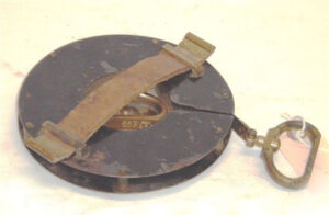
The tape above is one chain long. It is calibrated in links on one side and in feet on the other side and is marked “Chesterman Sheffield England.” The reel is marked “No 1650 Patent, Chesterman Sheffield England.”
The source is unknown.
ALSA 2007.01.01
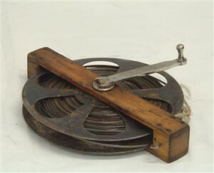
1/8 inch 500-link steel tape. It is graduated in links, poles, and chains. The tape is marked “The Lufkin Rule Company of Canada, Ltd. Barrie, Ontario”. The metal reel is marked “Lufkin, Made in USA”. 1/8-inch-wide tapes were more likely to break, but because they were lighter, they enabled more accurate measurements over long distances, such as over gullies or bodies of water where the tape is unsupported.
Donated by the Alberta Director of Surveys
ALSA 2007.21.04
By 1892, for ordinary township work, the sixty-six-foot Gunter’s chain or a steel band could be used. It was not until the 1903 Fifth Edition of the Manual of Instructions for the Survey of Dominion Lands that the option to use the Gunter’s chain was dropped altogether and only steel band chains could be used. However, for surveys other than Dominion Land Surveys, the Gunter’s chain continued to be sold and used by surveyors well into the 20th century.
Sources of Information:
- Surveyor General of Canada Lands Website, Dominion Lands manuals:
a. 1871 First Edition of the Manual Shewing the System of Survey adopted for the Public Lands of Canada: page 11, para. 6.
b. December 31, 1979, Memorandum to accompany Instructions for the Survey of Standard Meridians and Parallels forming the outline of Blocks of Sixteen Townships: pages 53, 54.
c. 1881 Second Edition of the Manual Showing the System of Survey of the Dominion Lands: page 10, para. 2 and page 19.
d.1892 Fourth Edition of the Manual showing the System of Survey of the Dominion Lands: page 17, para. 45.
e. 1903 Fifth Edition of the Manual of Instructions for the Survey of Dominion Lands, page 13, para. 72. - William Ogilvie, D.L.S. Reminiscences of Camp Life on Surveys in the North-West during the last Thirty Years, Program of the Association of Dominion Land Surveyors at its Sixth Annual Meeting , Ottawa, March 5th and 6th, 1912.
Author: Gordon Olsson, ALS (Hon. Life)
November 9, 2021
Copyright 2024 © Alberta Geomatics Historical Society